
Pricing Change
New pricing for orders of material from this site will come into place shortly. Charges for supply of digital images, digitisation on demand, prints and licensing will be altered.
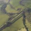
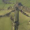
Avon Viaduct


Rig And Furrow (Medieval) - (Post Medieval)
Site Name Avon Viaduct
Classification Rig And Furrow (Medieval) - (Post Medieval)
Alternative Name(s) River Avon
Canmore ID 299614
Site Number NS97SW 83
NGR NS 93344 72651
NGR Description Centred NS 93344 72651
Datum OSGB36 - NGR
Permalink http://canmore.org.uk/site/299614


- Council Falkirk
- Parish Muiravonside
- Former Region Central
- Former District Falkirk
- Former County Stirlingshire
NS97SW 83 centred 93344 72651
A small area of rig and furrow cultivation has been identified from oblique aerial views (RCAHMSAP 2009) immediately W of the Avon Viaduct (NS97SW 34) on the N bank of the River Avon. Situated on sloping ground it extends for about 0.14 hectares and has a seasonal water course running through it.
Information from RCAHMS (DE), July 2009.

