
Pricing Change
New pricing for orders of material from this site will come into place shortly. Charges for supply of digital images, digitisation on demand, prints and licensing will be altered.
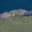
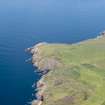
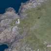
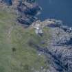
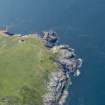
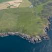
Crammag Head, Beacon


Beacon (Period Unassigned)
Site Name Crammag Head, Beacon
Classification Beacon (Period Unassigned)
Alternative Name(s) Crammag Head Light; North Channel
Canmore ID 299531
Site Number NX03SE 8
NGR NX 08889 34046
Datum OSGB36 - NGR
Permalink http://canmore.org.uk/site/299531


- Council Dumfries And Galloway
- Parish Kirkmaiden
- Former Region Dumfries And Galloway
- Former District Wigtown
- Former County Wigtownshire
NX03SE 8 08889 34046
Crammag Head Light [NAT]
OS 1:10,000 map, 1984.
This major automatic light has a tower 6m high.
K Allardyce and E M Hood 1986.
Crammag Head Light [NAT]
OS (GIS) MasterMap, July 2009.

