
Pricing Change
New pricing for orders of material from this site will come into place shortly. Charges for supply of digital images, digitisation on demand, prints and licensing will be altered.
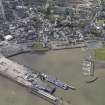
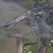
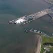
Stranraer Harbour, Ross Pier


Pier (Period Unassigned)
Site Name Stranraer Harbour, Ross Pier
Classification Pier (Period Unassigned)
Alternative Name(s) East Pier; Railway Pier; Loch Ryan
Canmore ID 299358
Site Number NX06SE 33.03
NGR NX 06040 61353
NGR Description NX 06040 61353 to NX c. 06151 61232
Datum OSGB36 - NGR
Permalink http://canmore.org.uk/site/299358


- Council Dumfries And Galloway
- Parish Stranraer
- Former Region Dumfries And Galloway
- Former District Wigtown
- Former County Wigtownshire
NX06SE 33.03 06040 61353 to c. 06151 61232
Ross Pier [NAT] (at NX 0609 6130)
OS (GIS) MasterMap, July 2009.
Thios structure is integral with the East (or Railway) Pier (NX 06079 61501 to NX c. 06482 60935), for which see NX06SE 33.01.
Information from RCAHMS (RJCM), 14 July 2009.

