
Following the launch of trove.scot in February 2025 we are now planning the retiral of some of our webservices. Canmore will be switched off on 24th June 2025. Information about the closure can be found on the HES website: Retiral of HES web services | Historic Environment Scotland
Gullane, Saltcoats Road, Saltcoats House


Farmstead (18th Century)
Site Name Gullane, Saltcoats Road, Saltcoats House
Classification Farmstead (18th Century)
Alternative Name(s) Saltcoats Farmstead
Canmore ID 297937
Site Number NT48SE 180
NGR NT 48453 81846
Datum OSGB36 - NGR
Permalink http://canmore.org.uk/site/297937


- Council East Lothian
- Parish Dirleton
- Former Region Lothian
- Former District East Lothian
- Former County East Lothian
NT48SE 180 48453 81846
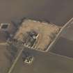
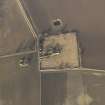
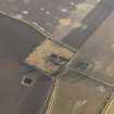
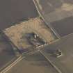
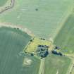
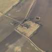
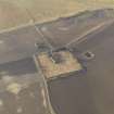
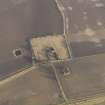
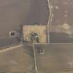
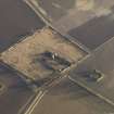
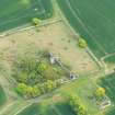
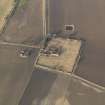
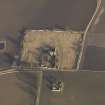
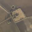
An unroofed farmstead has been identified from oblique aerial views (RCAHMSAP 2009), about 100m W of Saltcoats Castle (NT48SE7). The three buildings are set around a farmyard with the main house on the W side.
The farmstead is depicted as roofed on the 1st Edition of the OS 6-inch map (Haddingtonshire, 1854, sheet 4) which annotates it as 'Saltcoats House', the Object Name Book of the Ordnance Survey (ONB) noting it as 'Saltcoats'. The Name Book describes the buildings as' A farm house having extensive offices (including a threshing machine) attached. Occupied by S B Sherriff, the property of Maj. Hope of Luffness' (Name Book 1853).

