
Douglas, Colonel's Entry, Gallow Knowe, Military Camp


Military Camp (20th Century)
Site Name Douglas, Colonel's Entry, Gallow Knowe, Military Camp
Classification Military Camp (20th Century)
Alternative Name(s) Burnhouse Burn
Canmore ID 297534
Site Number NS83SW 72
NGR NS 83767 31106
NGR Description Centred NS 83767 31106
Datum OSGB36 - NGR
Permalink http://canmore.org.uk/site/297534


- Council South Lanarkshire
- Parish Douglas
- Former Region Strathclyde
- Former District Clydesdale
- Former County Lanarkshire
NS83SW 72.00 centred 83667 31106
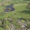
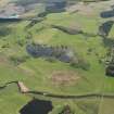
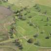
A small military camp has been identified from vertical air photographs taken in 1946 (196G/Scot/UK 87, frmaes 4073-4075, flown 10 May 1946), immediately NE of Douglas town. The camp lay between Colonel's Entry and Gallow Knowe.
At least 25 huts are visible on the air photographs, some of which are of the Nissen type.
The presence of a memorial to Polish military services (NS83SW 72.01), would suggest that this camp may have been occupied by soldiers from Poland.
The air photographs also show the presence of large numbers of redundant vehicles to the S and N of the small loch. These vehicles are also noted in photographs of the fomer prisoner-of-war camp at Happendon (NS83SE 24).
The outlines of some of the huts are shown on the current OS digital maps and the area annotated as 'Camp (dis) and they are also visible on recent oblique air views taken by RCAHMS (RCAHMSAP 2008).
Inforation from RCAHMS (DE), January 2009

