
Chirnsidebridge, Rockcliffe


House (19th Century)
Site Name Chirnsidebridge, Rockcliffe
Classification House (19th Century)
Canmore ID 296976
Site Number NT85NE 111
NGR NT 85155 56547
Datum OSGB36 - NGR
Permalink http://canmore.org.uk/site/296976


- Council Scottish Borders, The
- Parish Edrom
- Former Region Borders
- Former District Berwickshire
- Former County Berwickshire
NT85NE 111 85155 56547
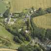
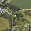
A two storey hipped roof house has been identified from oblique aerial views (RCAHMSAP 2007), situated immediately E of a dismantled railway and N of the Paper Mill (NT85NE 61.00). Set in about 0.30 hectares of garden it has two bay windows on the SW-facing elevation. Immediately to the SW is a terraced garden with steps.
The house is first depicted on the 2nd edtion of the OS 25-inch map (Berwickshire, 1898-1899), but is not annotated. The current OS digital maps annotate the house 'Rockcliffe'.
Information from RCAHMS (DE), November 2008

