
Balblair, Newhall Point


Military Installation (20th Century)(Possible)
Site Name Balblair, Newhall Point
Classification Military Installation (20th Century)(Possible)
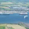
Alternative Name(s) Cromarty Firth
Canmore ID 296881
Site Number NH76SW 77
NGR NH 7089 6695
NGR Description c.NH 7089 6695
Datum OSGB36 - NGR
Permalink http://canmore.org.uk/site/296881


- Council Highland
- Parish Resolis
- Former Region Highland
- Former District Ross And Cromarty
- Former County Ross And Cromarty
NH76SW 77 c.7089 6695
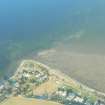
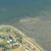
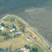
A semi-rectangular enclosure has been identified from vertical air photographs taken in 1945 (106G/UK 751, frames 5060-5062, flown 31 August 1945), situated at the edge of the raised beach S of Newhall Point. The photographs show it lies about 221m S of the Point and W of a fence line which is above a short row of modern houses.
Visible on the air photographs is what may be an earth-banked enclosure with a possible ditch on the N side and another ditch running through the middle. Within the enclosure are at least six buildings, huts and what may be an open water tank. Two of the huts may be shortened Nissen types.
No evidence has yet been found linking this site to military activity, however, it's appearance would suggest such a use during wartime. In addition the OS 6-inch map of 1951 shows no enclosure or buildings at this location as do the pre-war editions of the OS maps, and the fact that it appears on photographs dated 1945 would suggest a wartime use.
Information from RCAHMS (DE), November 2008

