
Pricing Change
New pricing for orders of material from this site will come into place shortly. Charges for supply of digital images, digitisation on demand, prints and licensing will be altered.
Fortingall


Pit (Period Unassigned), Revetment(S) (Period Unassigned)
Site Name Fortingall
Classification Pit (Period Unassigned), Revetment(S) (Period Unassigned)
Canmore ID 296264
Site Number NN74NW 85
NGR NN 7410 4690
Datum OSGB36 - NGR
Permalink http://canmore.org.uk/site/296264


- Council Perth And Kinross
- Parish Fortingall
- Former Region Tayside
- Former District Perth And Kinross
- Former County Perthshire
Watching Brief (24 July 2007 - 1 August 2007)
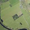
NN 7410 4690 An archaeological watching brief was requested by Historic Scotland during the excavation of two new sewer pipes, the course of which encroached on a scheduled ancient monument area. These works, carried out from 24 July–1 August 2007 found a stone-built revetment wall cut into a river terrace. A large wall foundation was also noted in one pipe trench as well as a small charcoal-rich pit. All these features apart from the pit correspond to features visible in oblique aerial photographs of the scheduled ancient monument area.
A further archaeological watching brief was requested by Historic Scotland during works to replace sewer pipes. The watching brief was requested because the new pipes had to traverse a scheduled ancient monument believed to be a monastic vallum. Two new pipe trenches were excavated varying between 0.75m and 1m wide and up to 1.7m deep. Corresponding with the cropmark responsible for demarcation of the scheduled monument was seen the remains of a possible revetment wall cut into the S face of a river terrace. A corresponding feature was seen cutting pipe trench 2, although the revetment wall was seen to be demolished with the remains lying at the base of the river terrace. No evidence for a ditch or vallum was observed and it is believed that the river terrace was excavated providing material for a bank which was retained by the revetment. No datable finds were recovered from the features, although material may
be recovered from soil samples.
Archive to be deposited with RCAHMS.
Funder: Kilmartin Property Group.

