
Pricing Change
New pricing for orders of material from this site will come into place shortly. Charges for supply of digital images, digitisation on demand, prints and licensing will be altered.
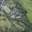
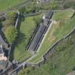
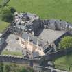
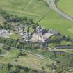
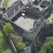
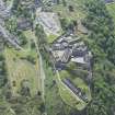
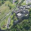
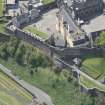
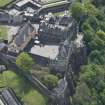
Stirling Castle, Nether Bailey


Bailey (Medieval)
Site Name Stirling Castle, Nether Bailey
Classification Bailey (Medieval)
Canmore ID 295185
Site Number NS79SE 6.18
NGR NS 78967 94153
NGR Description Centred NS 78967 94153
Datum OSGB36 - NGR
Permalink http://canmore.org.uk/site/295185


- Council Stirling
- Parish Stirling
- Former Region Central
- Former District Stirling
- Former County Stirlingshire
Watching Brief (7 August 2000 - 9 August 2000)
A watching brief was maintained at Stirling Castle over a period of 3 days from the 7th to the 9th of August while the MCU excavated a pipe trench through the E gateway of the protective wall surrounding the Nether Bailey powder magazines. The purpose of the work was to put in place a waste water pipe to link up the E end of the powder magazine and a small stone building positioned within the perimeter wall at its NE corner to the main sewer which runs W down through the Nether Bailey several metres below the granite setts of the access road. In general terms the new sandstone paving seems fairly recent and most of the disturbances appear to have taken place over a period probably not exceeding the last 50 years or so.
Sponsor: Historic Scotland
P Fox 2000
Kirkdale Archaeology
Aerial Photography (25 April 2008)
NS79SE 6.18 centred 78967 94153
Nether Bailey situated on the NE side of the main castle area.
Watching Brief (9 November 2010 - 10 November 2010)
NS 7894 9419 A watching brief was maintained 9–10 November 2010 during the excavation of 150 shallow holes, for gorse plants, on high ground N of the Powder Magazine. The excavations showed that apart from the presence of material relating to the modern shooting range the area had been previously undisturbed to a depth of 0.3m.
Archive: RCAHMS (intended)
Funder: Historic Scotland
Kirkdale Archaeology, 2010

