
Spinningdale: Village Bay, Hirta, St Kilda, Atlantic


Motor Trawler (21st Century)
Site Name Spinningdale: Village Bay, Hirta, St Kilda, Atlantic
Classification Motor Trawler (21st Century)
Alternative Name(s) Spinningdale
Canmore ID 295175
Site Number NF09NE 8009
NGR NF 09948 98922
NGR Description NF c. 1049 9899
Datum WGS84 - Lat/Long
Permalink http://canmore.org.uk/site/295175


- Council Western Isles
- Parish Maritime - Western Isles
- Former Region Western Isles Islands Area
- Former District Maritime
- Former County Not Applicable
NF19NW 8005 c. 1049 9899
N57 48.64 W8 33.72
NLO: St Kilda [name: NF 09 99].
Possibly on map sheet NF09NE.
Formerly also entered as NF09NW 8001: location formerly also cited as NF c. 103 989 [N57 48.6 W8 33.9 and NF c. 10 98 [N57 48 W8 34].
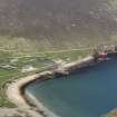
The fishing boat [motor fishing vessel] Spinningdale ran aground and was wrecked on Hirta, the main island of the St Kilda archipelago during a storm in February 2008. The 14-strong crew was rescued.
Source: BBC News, 21 June 2008.
The 82ft [25m] motor trawler stranded at the foot of cliffs on Hirta, St Kilda, in February 2008.
[No accurate location cited: illustrated].
Source: Times 23 June 2008.
The location assigned to this record is essentially arbitrary. The published photograph depicts the vessel as intact and upright. Hirta or Hiort is the main island of the St Kilda group.
Information from RCAHMS (RJCM), 6 July 2008.
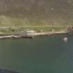
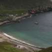
The wreck of this vessel remains in situ, tucked into the foot of the cliff amongst rocks to S of the Factor's House [NF19NW 21.45: NF 1030 9924] on the E side of Village Bay. The NTS have no intention of removing it.
Information from RCAHMS (ARG), 7 July 2008.
A location at NF c. 103 989 appears appropriate to this record.
Village Bay is not noted as such on the 1996 edition of the OS 1:50,000 map, but the name applies to the prominent indentation, which is also known as Bagh a' Bhaile or Loch Hiort, set into the SE side of Hirta or Hiort, the main island of the St Kilda group.
Information from RCAHMS (RJCM), 17 July 2008.
The correct location for this wreck is NF c. 1049 9899.
Information from RCAHMS (IGP), 21 July 2008.
This vessel has now split into two, the stern having broken away. The bow and midships portion has been washed up to a point hard against the base of the cliff.
Visited by RCAHMS (DRE), 5 May 2009.
Loss (February 2008)
The fishing boat [motor fishing vessel] Spinningdale ran aground and was wrecked on Hirta, the main island of the St Kilda archipelago during a storm in February 2008. The 14-strong crew was rescued.
Source: BBC News, 21 June 2008.
The 82ft [25m] motor trawler stranded at the foot of cliffs on Hirta, St Kilda, in February 2008.
[No accurate location cited: illustrated].
Source: Times 23 June 2008.
Note (7 July 2008)
The wreck of this vessel remains in situ, tucked into the foot of the cliff amongst rocks to S of the Factor's House [NF19NW 21.45: NF 1030 9924] on the E side of Village Bay. The NTS have no intention of removing it.
Information from RCAHMS (ARG), 7 July 2008.
Note (17 July 2008)
A location at NF c. 103 989 appears appropriate to this record.
Information from RCAHMS (RJCM), 17 July 2008.
Note (21 July 2008)
The correct location for this wreck is NF c. 1049 9899.
Information from RCAHMS (IGP), 21 July 2008.
Note (5 May 2009)
This vessel has now split into two, the stern having broken away. The bow and midships portion has been washed up to a point hard against the base of the cliff.
Visited by RCAHMS (DRE), 5 May 2009.
Reference (19 April 2012)
UKHO Identifier : 071252
Feature Class : Wreck
Wreck Category : Wreck showing any portion of hull or superstructure
State : LIVE
Classification : Unclassified
Position (Lat/long) : 57.80917,-8.57167
Horizontal Datum : ETRS 1989
WGS84 Position (Lat/long) : 57.80917,-8.57167
WGS84 Origin : Original
Position Quality : Unreliable
Depth Quality : Depth unknown
Water Depth : 2
Vertical Datum : Mean Low Water Springs
Name : SPINNINGDALE
Type : M TRAWLER
Flag : BRITISH
Length : 26.3
Beam : 6.2
Draught : 3.3
Tonnage : 169
Tonnage Type : Gross
Date Sunk : 01/02/2008
Bottom Texture : Rock
Contact Description : Entire wreck
Original Sensor : Reported Sinking
Original Detection Year : 2008
Original Source : Other
Circumstances of Loss : **BUILT IN 1968 BY J LEWIS & SONS LTD, ABERDEEN. OWNED AT TIME OF LOSS BY BURLORT LTD, MILFORD HAVEN. OIL ENGINE OF 664BHP, SINGLE SHAFT. A LONGLINER. RAN AGROUND. CREW RECOVERED BY COASTGUARD HELICOPTER. (FVGB & LL).
Surveying Details : **13.2.08 RAN AGROUND IN 5748.5N, 0834.0W. (LL, 4.2.08). BBC PHOTO SHOWED WK AT BASE OF CLIFF. POSN 5748.55N, 0834.30W FOR FILING ONLY.
**28.3.08 MAMMOT SALVAGE, NETHERLANDS, HAVE BEEN APPOINTED TO SALVAGE VESSEL. (LL, 20.3.08). NCA.
General Comments : AGROUND AT BASE OF CLIFF
Charting Comments : POSN FOR FILING ONLY
Date Last Amended : 13/02/2008

