
Pricing Change
New pricing for orders of material from this site will come into place shortly. Charges for supply of digital images, digitisation on demand, prints and licensing will be altered.
Lair


Pitcarmick Building (Early Medieval)
Site Name Lair
Classification Pitcarmick Building (Early Medieval)
Canmore ID 29513
Site Number NO16SW 51
NGR NO 1375 6392
Datum OSGB36 - NGR
Permalink http://canmore.org.uk/site/29513


- Council Perth And Kinross
- Parish Kirkmichael (Perth And Kinross)
- Former Region Tayside
- Former District Perth And Kinross
- Former County Perthshire
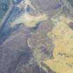
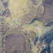
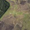
Field Visit (2 October 1987)
Situated on a low, heather-covered terrace some 730m NW of Lair cottage and overlooking poorly-drained ground to the S, there are the remains of a building. It measures 17m NNW-SSE by 7m in width at the NNW end and 5.5m in width at the SSE end over walls reduced to a low bank some 1.6m in thickness and 0.1m in height. The ends of the building are rounded and the SSE half of the interior is sunken; the entrance is situated on WSW side close to the SSE end.
Visited by RCAHMS (JRS) 2 October 1987.
RCAHMS 1990

