
Mallard: Dunstaffnage, Firth Of Lorn


Yacht (20th Century)
Site Name Mallard: Dunstaffnage, Firth Of Lorn
Classification Yacht (20th Century)
Alternative Name(s) Dun Staffnage Bay; Loch Linnhe; Mallard
Canmore ID 294267
Site Number NM83SE 8026
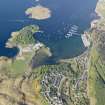
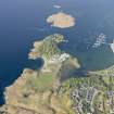
NGR NM 88651 34096
NGR Description NM c. 886 341
Datum WGS84 - Lat/Long
Permalink http://canmore.org.uk/site/294267


- Council Argyll And Bute
- Parish Maritime - Argyll And Bute
- Former Region Strathclyde
- Former District Maritime
- Former County Not Applicable
NM83SE 8026 c. 886 341
N56 27.1 W5 25.8
NLO: Dunstaffnage Bay [name centred NM 886 341]
Firth of Lorn [name centred NM 69 19]
Loch Linnhe [name centred NM 86 47].
(Classified as Yacht: date of loss cited as 14 January 1975). Mallard: this vessel sank in Dun Staffnage [Dunstaffnage] Bay, 110 yards off the South coast. Length: 6m.
(Location of loss cited as N56 27.10 W5 25.80).
I G Whittaker 1998.
The location assigned to this record is essentially tentative.
Information from RCAHMS (RJCM), 2 May 2008.
Reference (2011)
Whittaker ID : 1984
Name : MALLARD
Latitude : 562706
Longitude : 52548
Type : YACHT
Length : 6
Position : Position Approximate
Loss Day : 14
Loss Month : 1
Loss Year : 1975
Comment : Sunk in Dun Staffnage Bay 110 yds off south coast
Reference (19 April 2012)
UKHO Identifier : 002704
Feature Class : Wreck
State : LIVE
Classification : Unclassified
Position (Lat/long) : 56.45167,-5.43000
Horizontal Datum : ORDNANCE SURVEY OF GREAT BRITAIN (1936)
WGS84 Position (Lat/long) : 56.45151,-5.43113
WGS84 Origin : 3-D Cartesian Shift (BW)
Previous Position : 56.45167,-5.43000
Position Quality : Unreliable
Depth Quality : Depth unknown
Water Depth : 4
Vertical Datum : Lowest Astronomical Tide
Name : MALLARD
Type : YACHT
Flag : BRITISH
Length : 5.5
Date Sunk : 14/01/1975
Contact Description : Entire wreck
Original Sensor : Reported Sinking
Original Detection Year : 1975
Original Source : Other
Circumstances of Loss : **SUNK AS DERELICT.
Surveying Details : **H1270/74 28.1.75 SUNK IN DUNSTAFFNAGE BAY 110YDS OFF SOUTH COAST OFF FISH RAFTS. (RECEIVER OF WKS, OBAN 15.1.75). POSN 5627.100N, 0525.800W [OGB] FOR FILING ONLY.
Charting Comments : POSN FOR FILING ONLY
Date Last Amended : 05/12/2003
Date Position Last Amended : 05/12/2003

