
Nethercraig, Farm


Farm (Period Unassigned), Farmstead (19th Century)
Site Name Nethercraig, Farm
Classification Farm (Period Unassigned), Farmstead (19th Century)
Alternative Name(s) Nethercraig Farmstead (New)
Canmore ID 294143
Site Number NS55SE 410
NGR NS 59526 50955
Datum OSGB36 - NGR
Permalink http://canmore.org.uk/site/294143


- Council East Renfrewshire
- Parish Eaglesham
- Former Region Strathclyde
- Former District Eastwood
- Former County Renfrewshire
NS55SE 410 59526 50955
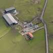
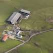
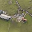
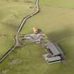
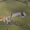
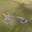
The late 19th century farmstead of Nethercraig, which replaced that situated about 78m to the SE (NS55SE 12).
The farmstead is depicted on the 2nd edition of the OS 25-inch map (Renfrewshire, 1897, sheet 19), but not on the 1st edition (1857).
Information from RCAHMS (DE), April 2008
Field Walking (2008 - 2009)
Fieldwalking
Robin Hunter, Susan Hunter and Janie Munro – ACFA
NS 5924 5144, NS 5897 5104, NS 5990 5090 and NS 5962 5055 We fieldwalked the farmlands of Nethercraig Farm and recorded various quarrying activities, trackways, agricultural and water management features in the winter of 2008 and spring of 2009 using a Garmin GPS12 XL
NS 59558 51007, NS 59591 51187 2.5m W turf-covered trackway from Nethercraigs Farm which originally ran to Nethercraigs Bridge on the White Cart Water at NS 59591 51187. The bridge has now disappeared, although it may have survived up to the 1920s.
Archive: Paper – RCAHMS and WoSAS SMR

