
Hill Of Avochie 1


Cup And Ring Marked Rock (Neolithic) - (Bronze Age)
Site Name Hill Of Avochie 1
Classification Cup And Ring Marked Rock (Neolithic) - (Bronze Age)
Canmore ID 294037
Site Number NJ54NW 75
NGR NJ 54173 46545
NGR Description 54173 46545 and 54028 46569
Datum OSGB36 - NGR
Permalink http://canmore.org.uk/site/294037


- Council Aberdeenshire
- Parish Huntly
- Former Region Grampian
- Former District Gordon
- Former County Aberdeenshire
NJ54NW 75 54173 46545
NJ 54173 46545 A boulder 3.5 x 3.0 x 1.4m bears at least 15 cup marks, the largest two measuring 70 x 20mm.
NJ 54028 46569 On the W-facing slope of Hill of Avochie a pointed rock 1.1 x 0.8m flush with the ground bears nine cup marks. 9m SSE, a turf-covered rock bears three cups.
George Currie, 2006.
Field Visit (2006)
NJ 54173 46545 A boulder 3.5 x 3.0 x 1.4m bears at least 15 cup marks, the largest two measuring 70 x 20mm.
NJ 54028 46569 On the W-facing slope of Hill of Avochie a pointed rock 1.1 x 0.8m flush with the ground bears nine cup marks. 9m SSE, a turf-covered rock bears three cups.
G Currie 2006
Field Visit (10 June 2011)
Cup-marked rock, Avochie South 1. Cup-marked rock with two good cups and one badly weathered cup in the field to the S of the ‘famous stone’. The site was recorded on 10 June 2011.
Alexander Jarvie 2011
Note (27 November 2020)
Date Fieldwork Started: 27/11/2020
Compiled by: NOSAS
Location Notes: This panel is located on a gentle E facing slope, just below the top of the Hill of Avochie. From this location Knock Hill can be seen to the N; Ben Rhinnes to the E and Tap O'Noth to the S. Situated approximately 200m to the E of the track to the Quarry, the panel is within a fenced area, which is within a larger fenced area. The enclosed areas are stony rough pasture and are used for grazing livestock. A further four panels of rock art have been identified in the near vicinity- Hill of Avochie 2 (NJ 54028 46569) and Hill of Avochie 3 (N57 30420 W0024612) lie on the W side of the plateau. Avochie (NJ 53980 46840) is approximately 350m to the W and Avochie South 1 in the field to the S of Avochie., and were previously grouped with Hill of Avochie 1 under the same Canmore ID (294037).
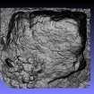
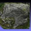
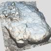
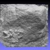
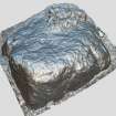
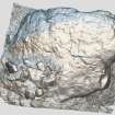
Panel Notes: This large rock measures approximately 4.0m x 3.6m with its long axis orientated WE. The W end of the panel rises to approximately 2.0m and gradually tapers to ground level at the E end. The NE of the panel is bordered with turf and a cluster of field cleared stones. Natural cracks are present, mainly running N-S across the surface. A total of 25 cups were identified, as well as 2 cups with single rings, and a cup with single penannular and radial.
Additional Description: "NJ 54173 46545 A boulder 3.5 x 3.0 x 1.4m bears at least 15 cup marks, the largest two measuring 70 x 20mm.
NJ 54028 46569 On the W-facing slope of Hill of Avochie a pointed rock 1.1 x 0.8m flush with the ground bears nine cup marks. 9m SSE, a turf-covered rock bears three cups.
G Currie 2006,Cup-marked rock, Avochie South 1. Cup-marked rock with two good cups and one badly weathered cup in the field to the S of the ëfamous stoneí. The site was recorded on 10 June 2011.
Alexander Jarvie 2011,NJ54NW 75 54173 46545
NJ 54173 46545 A boulder 3.5 x 3.0 x 1.4m bears at least 15 cup marks, the largest two measuring 70 x 20mm.
NJ 54028 46569 On the W-facing slope of Hill of Avochie a pointed rock 1.1 x 0.8m flush with the ground bears nine cup marks. 9m SSE, a turf-covered rock bears three cups.
George Currie, 2006."

