|
Manuscripts |
MS 726/167 |
Records of CFA Archaeology Ltd, archaeologists, Musselburgh, East Lothian, Scotland |
Coastal Assessment Survey: Inner Moray Firth, Volumes 1 and 2. |
14/12/1998 |
Item Level |
|
|
Manuscripts |
MS 2776/1/6 |
Historic Scotland Archive Project |
Survey archive: Site record sheets, site record sheets with field notes and monument forms from the Inner Moray Firth (Moray, Beauly and Cromarty Firth) Coastal Assessment Survey. Sheet 6. |
9/1998 |
Item Level |
|
|
Prints and Drawings |
BD 104/1/6 |
Historic Scotland Archive Project |
Survey archive: 1:25,000 OS Pathfinder map depicting site locations from the Moray, Beauly and Cromarty Firth Coastal Assessment Survey. Sheet 6. |
9/1998 |
Item Level |
|
 |
On-line Digital Images |
DP 068708 |
RCAHMS Aerial Photography Digital |
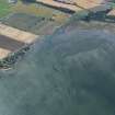
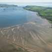
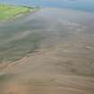
Oblque aerial view centred on the remains of fishtraps in Udale Bay, taken from the NE. |
5/8/2009 |
Item Level |
|
 |
On-line Digital Images |
DP 092016 |
RCAHMS Aerial Photography Digital |
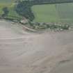
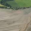
Oblique aerial view of the fish trap with Jemimaville beyond, looking to the SSE. |
22/7/2010 |
Item Level |
|
 |
On-line Digital Images |
DP 164119 |
RCAHMS Aerial Photography Digital |
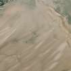
Oblique aerial view of a fish trap at Jemimaville, looking S. |
17/7/2013 |
Item Level |
|
 |
On-line Digital Images |
DP 164120 |
RCAHMS Aerial Photography Digital |
Oblique aerial view of a fish trap at Jemimaville, looking SSE. |
17/7/2013 |
Item Level |
|
 |
On-line Digital Images |
DP 191557 |
RCAHMS Aerial Photography Digital |
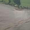
Oblique aerial view of the fish traps, looking SW. |
18/6/2014 |
Item Level |
|
 |
On-line Digital Images |
DP 191558 |
RCAHMS Aerial Photography Digital |
Oblique aerial view of the fish traps, looking SW. |
18/6/2014 |
Item Level |
|
 |
On-line Digital Images |
DP 191565 |
RCAHMS Aerial Photography Digital |
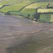
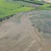
General oblique aerial view of Udale Bay and the fish traps, looking E. |
18/6/2014 |
Item Level |
|
 |
On-line Digital Images |
DP 191567 |
RCAHMS Aerial Photography Digital |
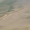
Oblique aerial view of the remains of the fish trap, looking N. |
18/6/2014 |
Item Level |
|
 |
On-line Digital Images |
DP 191568 |
RCAHMS Aerial Photography Digital |
General oblique aerial view of the remains of the fish traps, looking N. |
18/6/2014 |
Item Level |
|
 |
On-line Digital Images |
DP 191572 |
RCAHMS Aerial Photography Digital |
Oblique aerial view of the fish traps, looking SW. |
18/6/2014 |
Item Level |
|
|
Photographs and Off-line Digital Images |
BS 97/6 CS |
Historic Scotland Archive Project |
Survey photographs: From the Moray, Beauly and Cromarty Firth Coastal Assessment Survey ¿ Jemimaville, Udale Bay, Newhall Point, Blablair, Ferryton Point Pier and Alnessferry. |
1998 |
Batch Level |
|


