
Borland


Farmstead (Medieval) - (Post Medieval)
Site Name Borland
Classification Farmstead (Medieval) - (Post Medieval)
Canmore ID 29391
Site Number NO16SE 29
NGR NO 15292 61405
Datum OSGB36 - NGR
Permalink http://canmore.org.uk/site/29391
Ordnance Survey licence number AC0000807262. All rights reserved.
Canmore Disclaimer.
© Bluesky International Limited 2025. Public Sector Viewing Terms
- Correction
- Favourite

SC 2154676
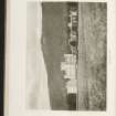
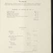
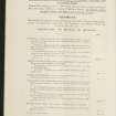
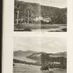
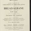
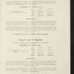
Estate Exchange. Taymouth Castle. No 1526 Sale Brochure Taymouth Castle, Kynachan Lodge, Glenquaich Lodge, Wester Kinloch Farm, Easter Kinloch Farm, Breadalbane Hotel Farm, Croft Nauld & Lynemore Farm, Comrie Farm, Errichel Farm, Borlick Farm, Borland Farm, South Amulree, Easter Auchnafauld, Wester Auchnafauld.
Collection of sale catalogues relating to Scottish estates
9/12/1920
© Courtesy of HES (Estates Exchange Collection)

SC 2154684
Estate Exchange. Taymouth Castle. No 1526 Sale Brochure Taymouth Castle, Kynachan Lodge, Glenquaich Lodge, Wester Kinloch Farm, Easter Kinloch Farm, Breadalbane Hotel Farm, Croft Nauld & Lynemore Farm, Comrie Farm, Errichel Farm, Borlick Farm, Borland Farm, South Amulree, Easter Auchnafauld, Wester Auchnafauld.
Collection of sale catalogues relating to Scottish estates
9/12/1920
© Courtesy of HES (Estates Exchange Collection)

SC 2154695
Estate Exchange. Taymouth Castle. No 1526 Sale Brochure Taymouth Castle, Kynachan Lodge, Glenquaich Lodge, Wester Kinloch Farm, Easter Kinloch Farm, Breadalbane Hotel Farm, Croft Nauld & Lynemore Farm, Comrie Farm, Errichel Farm, Borlick Farm, Borland Farm, South Amulree, Easter Auchnafauld, Wester Auchnafauld.
Collection of sale catalogues relating to Scottish estates
9/12/1920
© Courtesy of HES (Estates Exchange Collection)

SC 2154709
Estate Exchange. Taymouth Castle. No 1526 Sale Brochure Taymouth Castle, Kynachan Lodge, Glenquaich Lodge, Wester Kinloch Farm, Easter Kinloch Farm, Breadalbane Hotel Farm, Croft Nauld & Lynemore Farm, Comrie Farm, Errichel Farm, Borlick Farm, Borland Farm, South Amulree, Easter Auchnafauld, Wester Auchnafauld.
Collection of sale catalogues relating to Scottish estates
9/12/1920
© Courtesy of HES (Estates Exchange Collection)

SC 2154715
Estate Exchange. Taymouth Castle. No 1526 Sale Brochure Taymouth Castle, Kynachan Lodge, Glenquaich Lodge, Wester Kinloch Farm, Easter Kinloch Farm, Breadalbane Hotel Farm, Croft Nauld & Lynemore Farm, Comrie Farm, Errichel Farm, Borlick Farm, Borland Farm, South Amulree, Easter Auchnafauld, Wester Auchnafauld.
Collection of sale catalogues relating to Scottish estates
9/12/1920
© Courtesy of HES (Estates Exchange Collection)

SC 2154670
Estate Exchange. Taymouth Castle. No 1526 Sale Brochure Taymouth Castle, Kynachan Lodge, Glenquaich Lodge, Wester Kinloch Farm, Easter Kinloch Farm, Breadalbane Hotel Farm, Croft Nauld & Lynemore Farm, Comrie Farm, Errichel Farm, Borlick Farm, Borland Farm, South Amulree, Easter Auchnafauld, Wester Auchnafauld.
Collection of sale catalogues relating to Scottish estates
9/12/1920
© Courtesy of HES (Estates Exchange Collection)

SC 2154686
Estate Exchange. Taymouth Castle. No 1526 Sale Brochure Taymouth Castle, Kynachan Lodge, Glenquaich Lodge, Wester Kinloch Farm, Easter Kinloch Farm, Breadalbane Hotel Farm, Croft Nauld & Lynemore Farm, Comrie Farm, Errichel Farm, Borlick Farm, Borland Farm, South Amulree, Easter Auchnafauld, Wester Auchnafauld.
Collection of sale catalogues relating to Scottish estates
9/12/1920
© Courtesy of HES (Estates Exchange Collection)

SC 2154692
Estate Exchange. Taymouth Castle. No 1526 Sale Brochure Taymouth Castle, Kynachan Lodge, Glenquaich Lodge, Wester Kinloch Farm, Easter Kinloch Farm, Breadalbane Hotel Farm, Croft Nauld & Lynemore Farm, Comrie Farm, Errichel Farm, Borlick Farm, Borland Farm, South Amulree, Easter Auchnafauld, Wester Auchnafauld.
Collection of sale catalogues relating to Scottish estates
9/12/1920
© Courtesy of HES (Estates Exchange Collection)

SC 2154697
Estate Exchange. Taymouth Castle. No 1526 Sale Brochure Taymouth Castle, Kynachan Lodge, Glenquaich Lodge, Wester Kinloch Farm, Easter Kinloch Farm, Breadalbane Hotel Farm, Croft Nauld & Lynemore Farm, Comrie Farm, Errichel Farm, Borlick Farm, Borland Farm, South Amulree, Easter Auchnafauld, Wester Auchnafauld.
Collection of sale catalogues relating to Scottish estates
9/12/1920
© Courtesy of HES (Estates Exchange Collection)

SC 2154707
Estate Exchange. Taymouth Castle. No 1526 Sale Brochure Taymouth Castle, Kynachan Lodge, Glenquaich Lodge, Wester Kinloch Farm, Easter Kinloch Farm, Breadalbane Hotel Farm, Croft Nauld & Lynemore Farm, Comrie Farm, Errichel Farm, Borlick Farm, Borland Farm, South Amulree, Easter Auchnafauld, Wester Auchnafauld.
Collection of sale catalogues relating to Scottish estates
9/12/1920
© Courtesy of HES (Estates Exchange Collection)

SC 2154668
Estate Exchange. Taymouth Castle. No 1526 Sale Brochure Taymouth Castle, Kynachan Lodge, Glenquaich Lodge, Wester Kinloch Farm, Easter Kinloch Farm, Breadalbane Hotel Farm, Croft Nauld & Lynemore Farm, Comrie Farm, Errichel Farm, Borlick Farm, Borland Farm, South Amulree, Easter Auchnafauld, Wester Auchnafauld.
Collection of sale catalogues relating to Scottish estates
9/12/1920
© Courtesy of HES (Estates Exchange Collection)

SC 2154675
Estate Exchange. Taymouth Castle. No 1526 Sale Brochure Taymouth Castle, Kynachan Lodge, Glenquaich Lodge, Wester Kinloch Farm, Easter Kinloch Farm, Breadalbane Hotel Farm, Croft Nauld & Lynemore Farm, Comrie Farm, Errichel Farm, Borlick Farm, Borland Farm, South Amulree, Easter Auchnafauld, Wester Auchnafauld.
Collection of sale catalogues relating to Scottish estates
9/12/1920
© Courtesy of HES (Estates Exchange Collection)

SC 2154683
Estate Exchange. Taymouth Castle. No 1526 Sale Brochure Taymouth Castle, Kynachan Lodge, Glenquaich Lodge, Wester Kinloch Farm, Easter Kinloch Farm, Breadalbane Hotel Farm, Croft Nauld & Lynemore Farm, Comrie Farm, Errichel Farm, Borlick Farm, Borland Farm, South Amulree, Easter Auchnafauld, Wester Auchnafauld.
Collection of sale catalogues relating to Scottish estates
9/12/1920
© Courtesy of HES (Estates Exchange Collection)

SC 2154698
Estate Exchange. Taymouth Castle. No 1526 Sale Brochure Taymouth Castle, Kynachan Lodge, Glenquaich Lodge, Wester Kinloch Farm, Easter Kinloch Farm, Breadalbane Hotel Farm, Croft Nauld & Lynemore Farm, Comrie Farm, Errichel Farm, Borlick Farm, Borland Farm, South Amulree, Easter Auchnafauld, Wester Auchnafauld.
Collection of sale catalogues relating to Scottish estates
9/12/1920
© Courtesy of HES (Estates Exchange Collection)

SC 2154704
Estate Exchange. Taymouth Castle. No 1526 Sale Brochure Taymouth Castle, Kynachan Lodge, Glenquaich Lodge, Wester Kinloch Farm, Easter Kinloch Farm, Breadalbane Hotel Farm, Croft Nauld & Lynemore Farm, Comrie Farm, Errichel Farm, Borlick Farm, Borland Farm, South Amulree, Easter Auchnafauld, Wester Auchnafauld.
Collection of sale catalogues relating to Scottish estates
9/12/1920
© Courtesy of HES (Estates Exchange Collection)

SC 2154710
Estate Exchange. Taymouth Castle. No 1526 Sale Brochure Taymouth Castle, Kynachan Lodge, Glenquaich Lodge, Wester Kinloch Farm, Easter Kinloch Farm, Breadalbane Hotel Farm, Croft Nauld & Lynemore Farm, Comrie Farm, Errichel Farm, Borlick Farm, Borland Farm, South Amulree, Easter Auchnafauld, Wester Auchnafauld.
Collection of sale catalogues relating to Scottish estates
9/12/1920
© Courtesy of HES (Estates Exchange Collection)

SC 2154711
Estate Exchange. Taymouth Castle. No 1526 Sale Brochure Taymouth Castle, Kynachan Lodge, Glenquaich Lodge, Wester Kinloch Farm, Easter Kinloch Farm, Breadalbane Hotel Farm, Croft Nauld & Lynemore Farm, Comrie Farm, Errichel Farm, Borlick Farm, Borland Farm, South Amulree, Easter Auchnafauld, Wester Auchnafauld.
Collection of sale catalogues relating to Scottish estates
9/12/1920
© Courtesy of HES (Estates Exchange Collection)

SC 2154713
Estate Exchange. Taymouth Castle. No 1526 Sale Brochure Taymouth Castle, Kynachan Lodge, Glenquaich Lodge, Wester Kinloch Farm, Easter Kinloch Farm, Breadalbane Hotel Farm, Croft Nauld & Lynemore Farm, Comrie Farm, Errichel Farm, Borlick Farm, Borland Farm, South Amulree, Easter Auchnafauld, Wester Auchnafauld.
Collection of sale catalogues relating to Scottish estates
9/12/1920
© Courtesy of HES (Estates Exchange Collection)

SC 2154720
Estate Exchange. Taymouth Castle. No 1526 Sale Brochure Taymouth Castle, Kynachan Lodge, Glenquaich Lodge, Wester Kinloch Farm, Easter Kinloch Farm, Breadalbane Hotel Farm, Croft Nauld & Lynemore Farm, Comrie Farm, Errichel Farm, Borlick Farm, Borland Farm, South Amulree, Easter Auchnafauld, Wester Auchnafauld.
Collection of sale catalogues relating to Scottish estates
9/12/1920
© Courtesy of HES (Estates Exchange Collection)

SC 2154674
Estate Exchange. Taymouth Castle. No 1526 Sale Brochure Taymouth Castle, Kynachan Lodge, Glenquaich Lodge, Wester Kinloch Farm, Easter Kinloch Farm, Breadalbane Hotel Farm, Croft Nauld & Lynemore Farm, Comrie Farm, Errichel Farm, Borlick Farm, Borland Farm, South Amulree, Easter Auchnafauld, Wester Auchnafauld.
Collection of sale catalogues relating to Scottish estates
9/12/1920
© Courtesy of HES (Estates Exchange Collection)

SC 2154690
Estate Exchange. Taymouth Castle. No 1526 Sale Brochure Taymouth Castle, Kynachan Lodge, Glenquaich Lodge, Wester Kinloch Farm, Easter Kinloch Farm, Breadalbane Hotel Farm, Croft Nauld & Lynemore Farm, Comrie Farm, Errichel Farm, Borlick Farm, Borland Farm, South Amulree, Easter Auchnafauld, Wester Auchnafauld.
Collection of sale catalogues relating to Scottish estates
9/12/1920
© Courtesy of HES (Estates Exchange Collection)

SC 2154703
Estate Exchange. Taymouth Castle. No 1526 Sale Brochure Taymouth Castle, Kynachan Lodge, Glenquaich Lodge, Wester Kinloch Farm, Easter Kinloch Farm, Breadalbane Hotel Farm, Croft Nauld & Lynemore Farm, Comrie Farm, Errichel Farm, Borlick Farm, Borland Farm, South Amulree, Easter Auchnafauld, Wester Auchnafauld.
Collection of sale catalogues relating to Scottish estates
9/12/1920
© Courtesy of HES (Estates Exchange Collection)

SC 2154714
Estate Exchange. Taymouth Castle. No 1526 Sale Brochure Taymouth Castle, Kynachan Lodge, Glenquaich Lodge, Wester Kinloch Farm, Easter Kinloch Farm, Breadalbane Hotel Farm, Croft Nauld & Lynemore Farm, Comrie Farm, Errichel Farm, Borlick Farm, Borland Farm, South Amulree, Easter Auchnafauld, Wester Auchnafauld.
Collection of sale catalogues relating to Scottish estates
9/12/1920
© Courtesy of HES (Estates Exchange Collection)

SC 2154687
Estate Exchange. Taymouth Castle. No 1526 Sale Brochure Taymouth Castle, Kynachan Lodge, Glenquaich Lodge, Wester Kinloch Farm, Easter Kinloch Farm, Breadalbane Hotel Farm, Croft Nauld & Lynemore Farm, Comrie Farm, Errichel Farm, Borlick Farm, Borland Farm, South Amulree, Easter Auchnafauld, Wester Auchnafauld.
Collection of sale catalogues relating to Scottish estates
9/12/1920
© Courtesy of HES (Estates Exchange Collection)

SC 2154689
Estate Exchange. Taymouth Castle. No 1526 Sale Brochure Taymouth Castle, Kynachan Lodge, Glenquaich Lodge, Wester Kinloch Farm, Easter Kinloch Farm, Breadalbane Hotel Farm, Croft Nauld & Lynemore Farm, Comrie Farm, Errichel Farm, Borlick Farm, Borland Farm, South Amulree, Easter Auchnafauld, Wester Auchnafauld.
Collection of sale catalogues relating to Scottish estates
9/12/1920
© Courtesy of HES (Estates Exchange Collection)

SC 2154691
Estate Exchange. Taymouth Castle. No 1526 Sale Brochure Taymouth Castle, Kynachan Lodge, Glenquaich Lodge, Wester Kinloch Farm, Easter Kinloch Farm, Breadalbane Hotel Farm, Croft Nauld & Lynemore Farm, Comrie Farm, Errichel Farm, Borlick Farm, Borland Farm, South Amulree, Easter Auchnafauld, Wester Auchnafauld.
Collection of sale catalogues relating to Scottish estates
9/12/1920
© Courtesy of HES (Estates Exchange Collection)

SC 2154696
Estate Exchange. Taymouth Castle. No 1526 Sale Brochure Taymouth Castle, Kynachan Lodge, Glenquaich Lodge, Wester Kinloch Farm, Easter Kinloch Farm, Breadalbane Hotel Farm, Croft Nauld & Lynemore Farm, Comrie Farm, Errichel Farm, Borlick Farm, Borland Farm, South Amulree, Easter Auchnafauld, Wester Auchnafauld.
Collection of sale catalogues relating to Scottish estates
9/12/1920
© Courtesy of HES (Estates Exchange Collection)

SC 2154718
Estate Exchange. Taymouth Castle. No 1526 Sale Brochure Taymouth Castle, Kynachan Lodge, Glenquaich Lodge, Wester Kinloch Farm, Easter Kinloch Farm, Breadalbane Hotel Farm, Croft Nauld & Lynemore Farm, Comrie Farm, Errichel Farm, Borlick Farm, Borland Farm, South Amulree, Easter Auchnafauld, Wester Auchnafauld.
Collection of sale catalogues relating to Scottish estates
9/12/1920
© Courtesy of HES (Estates Exchange Collection)

SC 2154677
Estate Exchange. Taymouth Castle. No 1526 Sale Brochure Taymouth Castle, Kynachan Lodge, Glenquaich Lodge, Wester Kinloch Farm, Easter Kinloch Farm, Breadalbane Hotel Farm, Croft Nauld & Lynemore Farm, Comrie Farm, Errichel Farm, Borlick Farm, Borland Farm, South Amulree, Easter Auchnafauld, Wester Auchnafauld.
Collection of sale catalogues relating to Scottish estates
9/12/1920
© Courtesy of HES (Estates Exchange Collection)

SC 2154685
Estate Exchange. Taymouth Castle. No 1526 Sale Brochure Taymouth Castle, Kynachan Lodge, Glenquaich Lodge, Wester Kinloch Farm, Easter Kinloch Farm, Breadalbane Hotel Farm, Croft Nauld & Lynemore Farm, Comrie Farm, Errichel Farm, Borlick Farm, Borland Farm, South Amulree, Easter Auchnafauld, Wester Auchnafauld.
Collection of sale catalogues relating to Scottish estates
9/12/1920
© Courtesy of HES (Estates Exchange Collection)

SC 2154693
Estate Exchange. Taymouth Castle. No 1526 Sale Brochure Taymouth Castle, Kynachan Lodge, Glenquaich Lodge, Wester Kinloch Farm, Easter Kinloch Farm, Breadalbane Hotel Farm, Croft Nauld & Lynemore Farm, Comrie Farm, Errichel Farm, Borlick Farm, Borland Farm, South Amulree, Easter Auchnafauld, Wester Auchnafauld.
Collection of sale catalogues relating to Scottish estates
9/12/1920
© Courtesy of HES (Estates Exchange Collection)

SC 2154705
Estate Exchange. Taymouth Castle. No 1526 Sale Brochure Taymouth Castle, Kynachan Lodge, Glenquaich Lodge, Wester Kinloch Farm, Easter Kinloch Farm, Breadalbane Hotel Farm, Croft Nauld & Lynemore Farm, Comrie Farm, Errichel Farm, Borlick Farm, Borland Farm, South Amulree, Easter Auchnafauld, Wester Auchnafauld.
Collection of sale catalogues relating to Scottish estates
9/12/1920
© Courtesy of HES (Estates Exchange Collection)

SC 2154719
Estate Exchange. Taymouth Castle. No 1526 Sale Brochure Taymouth Castle, Kynachan Lodge, Glenquaich Lodge, Wester Kinloch Farm, Easter Kinloch Farm, Breadalbane Hotel Farm, Croft Nauld & Lynemore Farm, Comrie Farm, Errichel Farm, Borlick Farm, Borland Farm, South Amulree, Easter Auchnafauld, Wester Auchnafauld.
Collection of sale catalogues relating to Scottish estates
9/12/1920
© Courtesy of HES (Estates Exchange Collection)

SC 2154721
Estate Exchange. Taymouth Castle. No 1526 Sale Brochure Taymouth Castle, Kynachan Lodge, Glenquaich Lodge, Wester Kinloch Farm, Easter Kinloch Farm, Breadalbane Hotel Farm, Croft Nauld & Lynemore Farm, Comrie Farm, Errichel Farm, Borlick Farm, Borland Farm, South Amulree, Easter Auchnafauld, Wester Auchnafauld.
Collection of sale catalogues relating to Scottish estates
9/12/1920
© Courtesy of HES (Estates Exchange Collection)

SC 2154669
Estate Exchange. Taymouth Castle. No 1526 Sale Brochure Taymouth Castle, Kynachan Lodge, Glenquaich Lodge, Wester Kinloch Farm, Easter Kinloch Farm, Breadalbane Hotel Farm, Croft Nauld & Lynemore Farm, Comrie Farm, Errichel Farm, Borlick Farm, Borland Farm, South Amulree, Easter Auchnafauld, Wester Auchnafauld.
Collection of sale catalogues relating to Scottish estates
9/12/1920
© Courtesy of HES (Estates Exchange Collection)

SC 2154671
Estate Exchange. Taymouth Castle. No 1526 Sale Brochure Taymouth Castle, Kynachan Lodge, Glenquaich Lodge, Wester Kinloch Farm, Easter Kinloch Farm, Breadalbane Hotel Farm, Croft Nauld & Lynemore Farm, Comrie Farm, Errichel Farm, Borlick Farm, Borland Farm, South Amulree, Easter Auchnafauld, Wester Auchnafauld.
Collection of sale catalogues relating to Scottish estates
9/12/1920
© Courtesy of HES (Estates Exchange Collection)

SC 2154673
Estate Exchange. Taymouth Castle. No 1526 Sale Brochure Taymouth Castle, Kynachan Lodge, Glenquaich Lodge, Wester Kinloch Farm, Easter Kinloch Farm, Breadalbane Hotel Farm, Croft Nauld & Lynemore Farm, Comrie Farm, Errichel Farm, Borlick Farm, Borland Farm, South Amulree, Easter Auchnafauld, Wester Auchnafauld.
Collection of sale catalogues relating to Scottish estates
9/12/1920
© Courtesy of HES (Estates Exchange Collection)

SC 2154678
Estate Exchange. Taymouth Castle. No 1526 Sale Brochure Taymouth Castle, Kynachan Lodge, Glenquaich Lodge, Wester Kinloch Farm, Easter Kinloch Farm, Breadalbane Hotel Farm, Croft Nauld & Lynemore Farm, Comrie Farm, Errichel Farm, Borlick Farm, Borland Farm, South Amulree, Easter Auchnafauld, Wester Auchnafauld.
Collection of sale catalogues relating to Scottish estates
9/12/1920
© Courtesy of HES (Estates Exchange Collection)

SC 2154680
Estate Exchange. Taymouth Castle. No 1526 Sale Brochure Taymouth Castle, Kynachan Lodge, Glenquaich Lodge, Wester Kinloch Farm, Easter Kinloch Farm, Breadalbane Hotel Farm, Croft Nauld & Lynemore Farm, Comrie Farm, Errichel Farm, Borlick Farm, Borland Farm, South Amulree, Easter Auchnafauld, Wester Auchnafauld.
Collection of sale catalogues relating to Scottish estates
9/12/1920
© Courtesy of HES (Estates Exchange Collection)

SC 2154681
Estate Exchange. Taymouth Castle. No 1526 Sale Brochure Taymouth Castle, Kynachan Lodge, Glenquaich Lodge, Wester Kinloch Farm, Easter Kinloch Farm, Breadalbane Hotel Farm, Croft Nauld & Lynemore Farm, Comrie Farm, Errichel Farm, Borlick Farm, Borland Farm, South Amulree, Easter Auchnafauld, Wester Auchnafauld.
Collection of sale catalogues relating to Scottish estates
9/12/1920
© Courtesy of HES (Estates Exchange Collection)

SC 2154688
Estate Exchange. Taymouth Castle. No 1526 Sale Brochure Taymouth Castle, Kynachan Lodge, Glenquaich Lodge, Wester Kinloch Farm, Easter Kinloch Farm, Breadalbane Hotel Farm, Croft Nauld & Lynemore Farm, Comrie Farm, Errichel Farm, Borlick Farm, Borland Farm, South Amulree, Easter Auchnafauld, Wester Auchnafauld.
Collection of sale catalogues relating to Scottish estates
9/12/1920
© Courtesy of HES (Estates Exchange Collection)

SC 2154694
Estate Exchange. Taymouth Castle. No 1526 Sale Brochure Taymouth Castle, Kynachan Lodge, Glenquaich Lodge, Wester Kinloch Farm, Easter Kinloch Farm, Breadalbane Hotel Farm, Croft Nauld & Lynemore Farm, Comrie Farm, Errichel Farm, Borlick Farm, Borland Farm, South Amulree, Easter Auchnafauld, Wester Auchnafauld.
Collection of sale catalogues relating to Scottish estates
9/12/1920
© Courtesy of HES (Estates Exchange Collection)

SC 2154699
Estate Exchange. Taymouth Castle. No 1526 Sale Brochure Taymouth Castle, Kynachan Lodge, Glenquaich Lodge, Wester Kinloch Farm, Easter Kinloch Farm, Breadalbane Hotel Farm, Croft Nauld & Lynemore Farm, Comrie Farm, Errichel Farm, Borlick Farm, Borland Farm, South Amulree, Easter Auchnafauld, Wester Auchnafauld.
Collection of sale catalogues relating to Scottish estates
9/12/1920
© Courtesy of HES (Estates Exchange Collection)

SC 2154700
Estate Exchange. Taymouth Castle. No 1526 Sale Brochure Taymouth Castle, Kynachan Lodge, Glenquaich Lodge, Wester Kinloch Farm, Easter Kinloch Farm, Breadalbane Hotel Farm, Croft Nauld & Lynemore Farm, Comrie Farm, Errichel Farm, Borlick Farm, Borland Farm, South Amulree, Easter Auchnafauld, Wester Auchnafauld.
Collection of sale catalogues relating to Scottish estates
9/12/1920
© Courtesy of HES (Estates Exchange Collection)

SC 2154701
Estate Exchange. Taymouth Castle. No 1526 Sale Brochure Taymouth Castle, Kynachan Lodge, Glenquaich Lodge, Wester Kinloch Farm, Easter Kinloch Farm, Breadalbane Hotel Farm, Croft Nauld & Lynemore Farm, Comrie Farm, Errichel Farm, Borlick Farm, Borland Farm, South Amulree, Easter Auchnafauld, Wester Auchnafauld.
Collection of sale catalogues relating to Scottish estates
9/12/1920
© Courtesy of HES (Estates Exchange Collection)

SC 2154706
Estate Exchange. Taymouth Castle. No 1526 Sale Brochure Taymouth Castle, Kynachan Lodge, Glenquaich Lodge, Wester Kinloch Farm, Easter Kinloch Farm, Breadalbane Hotel Farm, Croft Nauld & Lynemore Farm, Comrie Farm, Errichel Farm, Borlick Farm, Borland Farm, South Amulree, Easter Auchnafauld, Wester Auchnafauld.
Collection of sale catalogues relating to Scottish estates
9/12/1920
© Courtesy of HES (Estates Exchange Collection)

SC 2154722
Estate Exchange. Taymouth Castle. No 1526 Sale Brochure Taymouth Castle, Kynachan Lodge, Glenquaich Lodge, Wester Kinloch Farm, Easter Kinloch Farm, Breadalbane Hotel Farm, Croft Nauld & Lynemore Farm, Comrie Farm, Errichel Farm, Borlick Farm, Borland Farm, South Amulree, Easter Auchnafauld, Wester Auchnafauld.
Collection of sale catalogues relating to Scottish estates
9/12/1920
© Courtesy of HES (Estates Exchange Collection)

SC 2154672
Estate Exchange. Taymouth Castle. No 1526 Sale Brochure Taymouth Castle, Kynachan Lodge, Glenquaich Lodge, Wester Kinloch Farm, Easter Kinloch Farm, Breadalbane Hotel Farm, Croft Nauld & Lynemore Farm, Comrie Farm, Errichel Farm, Borlick Farm, Borland Farm, South Amulree, Easter Auchnafauld, Wester Auchnafauld.
Collection of sale catalogues relating to Scottish estates
9/12/1920
© Courtesy of HES (Estates Exchange Collection)

SC 2154679
Estate Exchange. Taymouth Castle. No 1526 Sale Brochure Taymouth Castle, Kynachan Lodge, Glenquaich Lodge, Wester Kinloch Farm, Easter Kinloch Farm, Breadalbane Hotel Farm, Croft Nauld & Lynemore Farm, Comrie Farm, Errichel Farm, Borlick Farm, Borland Farm, South Amulree, Easter Auchnafauld, Wester Auchnafauld.
Collection of sale catalogues relating to Scottish estates
9/12/1920
© Courtesy of HES (Estates Exchange Collection)

SC 2154682
Estate Exchange. Taymouth Castle. No 1526 Sale Brochure Taymouth Castle, Kynachan Lodge, Glenquaich Lodge, Wester Kinloch Farm, Easter Kinloch Farm, Breadalbane Hotel Farm, Croft Nauld & Lynemore Farm, Comrie Farm, Errichel Farm, Borlick Farm, Borland Farm, South Amulree, Easter Auchnafauld, Wester Auchnafauld.
Collection of sale catalogues relating to Scottish estates
9/12/1920
© Courtesy of HES (Estates Exchange Collection)

SC 2154702
Estate Exchange. Taymouth Castle. No 1526 Sale Brochure Taymouth Castle, Kynachan Lodge, Glenquaich Lodge, Wester Kinloch Farm, Easter Kinloch Farm, Breadalbane Hotel Farm, Croft Nauld & Lynemore Farm, Comrie Farm, Errichel Farm, Borlick Farm, Borland Farm, South Amulree, Easter Auchnafauld, Wester Auchnafauld.
Collection of sale catalogues relating to Scottish estates
9/12/1920
© Courtesy of HES (Estates Exchange Collection)

SC 2154708
Estate Exchange. Taymouth Castle. No 1526 Sale Brochure Taymouth Castle, Kynachan Lodge, Glenquaich Lodge, Wester Kinloch Farm, Easter Kinloch Farm, Breadalbane Hotel Farm, Croft Nauld & Lynemore Farm, Comrie Farm, Errichel Farm, Borlick Farm, Borland Farm, South Amulree, Easter Auchnafauld, Wester Auchnafauld.
Collection of sale catalogues relating to Scottish estates
9/12/1920
© Courtesy of HES (Estates Exchange Collection)

SC 2154712
Estate Exchange. Taymouth Castle. No 1526 Sale Brochure Taymouth Castle, Kynachan Lodge, Glenquaich Lodge, Wester Kinloch Farm, Easter Kinloch Farm, Breadalbane Hotel Farm, Croft Nauld & Lynemore Farm, Comrie Farm, Errichel Farm, Borlick Farm, Borland Farm, South Amulree, Easter Auchnafauld, Wester Auchnafauld.
Collection of sale catalogues relating to Scottish estates
9/12/1920
© Courtesy of HES (Estates Exchange Collection)

SC 2154716
Estate Exchange. Taymouth Castle. No 1526 Sale Brochure Taymouth Castle, Kynachan Lodge, Glenquaich Lodge, Wester Kinloch Farm, Easter Kinloch Farm, Breadalbane Hotel Farm, Croft Nauld & Lynemore Farm, Comrie Farm, Errichel Farm, Borlick Farm, Borland Farm, South Amulree, Easter Auchnafauld, Wester Auchnafauld.
Collection of sale catalogues relating to Scottish estates
9/12/1920
© Courtesy of HES (Estates Exchange Collection)

SC 2154717
Estate Exchange. Taymouth Castle. No 1526 Sale Brochure Taymouth Castle, Kynachan Lodge, Glenquaich Lodge, Wester Kinloch Farm, Easter Kinloch Farm, Breadalbane Hotel Farm, Croft Nauld & Lynemore Farm, Comrie Farm, Errichel Farm, Borlick Farm, Borland Farm, South Amulree, Easter Auchnafauld, Wester Auchnafauld.
Collection of sale catalogues relating to Scottish estates
9/12/1920
© Courtesy of HES (Estates Exchange Collection)

SC 2399323
Borland, NO16SE 29, Ordnance Survey index card, Recto
Records of the Ordnance Survey, Southampton, Hampshire, England
c. 1958
© Crown Copyright: HES (Ordnance Survey Archaeology Division)


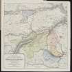


- Council Perth And Kinross
- Parish Alyth
- Former Region Tayside
- Former District Perth And Kinross
- Former County Perthshire
Field Visit (29 September 1988)
NO16SE 29 153 614
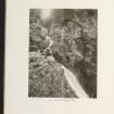
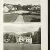
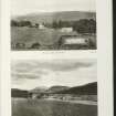
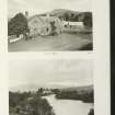
This farmstead comprises a well-preserved building with an enclosure, together with what are probably two earlier buildings.
The well-preserved building measures 9.8m NW to SE by 5.3m over clay-bonded walls 0.7m in thickness by up to 1m in height; the entrance is in the SW wall opening onto a stone-kerbed plinth which runs the length of the building. On the NW there is a small outshot measuring 2.7m in overall length into which a small lade runs. On the SE the line of the building is extended into the corner of the enclosure by an artificial terrace; the stone facing of the terrace is butted against the building as are the walls of the enclosure.
About 35m to the ENE there is a small building set at the SE corner of a yard. The building measures 6.7m from NNW to SSE by 4m over grass grown walls spread 1m in thickness by 0.3m in height.
A further 35m to the ESE (NO 1535 6141) there is a building measuring 7.3m from NW to SE by 4.3m over grass-grown walls, spread 1m in thickness by 0.2m in height.
Visited by RCAHMS (SPH) 29 September 1988.
RCAHMS 1990

