
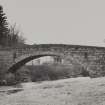
Bridge Of Brewlands


Road Bridge (Period Unassigned)
Site Name Bridge Of Brewlands
Classification Road Bridge (Period Unassigned)
Alternative Name(s) Old Bridge Of Brenlands; River Isla
Canmore ID 29386
Site Number NO16SE 24
NGR NO 19567 61437
Datum OSGB36 - NGR
Permalink http://canmore.org.uk/site/29386


- Council Angus
- Parish Glenisla
- Former Region Tayside
- Former District Angus
- Former County Angus
NO16SE 24 19567 61437
(Location cited as NO 196 614). Bridge of Brewlands, early 19th century. A graceful single segmental-arched rubble bridge.
J R Hume 1977.
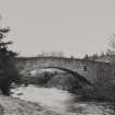
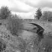
NO16SE 24 19567 61437
A single-span, segmentally arched rubble bridge.
J R Hume 1977

