
Skaill


Broch (Iron Age)(Possible), Settlement (Period Unassigned)
Site Name Skaill
Classification Broch (Iron Age)(Possible), Settlement (Period Unassigned)
Alternative Name(s) Howan; Deerness Church
Canmore ID 2935
Site Number HY50NE 21
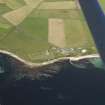
NGR HY 5889 0633
Datum OSGB36 - NGR
Permalink http://canmore.org.uk/site/2935


- Council Orkney Islands
- Parish St Andrews And Deerness
- Former Region Orkney Islands Area
- Former District Orkney
- Former County Orkney
HY50NE 21 5889 0633.
Howan (NAT) - a small sandy point, shown as a circle of pecks.
Name Book 1880; OS 6" map, Orkney 2nd ed., (1903).
A grass grown hillock S of the churchyard at Skaill may have been a broch. Coast erosion has revealed a deposit of typical broch refuse, and hammer stones and potsherds also typical were picked up in June 1930. Featureless dry-stone contruction was also noticed.
RCAHMS 1946, visited 4 June 1930.
At HY 5889 0633 there are grass covered traces of an inner circle 7.0m in diameter, of a possible bank or wall. The thin silt of black sand, shells and some bones in the bank facing the sea are still apparent, but no other evidence that this feature might have been a broch, could be found. The hammer stones and potsherds picked up at the site could not be located.
Surveyed at 1/2500.
Visited by OS (RD) 31 August 1964
To the NW of the church and close beside the bungalow (HY 5881 0638), there was a considerable open-area excavation of substantial late Bornze Age settlement which lay immediately below the ploughsoil. At the same time a trial trench was dug into the prominent mound known as the Howan (HY 5890 0633) SE of the church, which in 1930 was suggested as the site of a broch, and a dark deposit observed in the eroding shoreline. The Howan proved to be a sand-dune and the deeply-buried dark deposit is an ancient ploughsoil, in which ard-marks, probably of Bronze Age date, were found. In 1982, Mr Foubister encountered fragmentary prehistoric buildings between the Howan and the SE corner of the Churchyard dyke (HY 5886 0635).
RCAHMS 1987
Publication Account (2002)
HY50 3 DEERNESS CHURCH
HY/589063
Possible broch in Deerness, close to the sea shore south of the churchyard at Skaill, and appearing as a grass-grown hillock. Some potsherds of Iron Age type were found in 1928, in a thin dark layer exposed nearby at the shore [2], and two blocks of sandstone (one with a cup-mark and one with an incised design) may have come from this site [2]. In 1943 six sherds of reddish Iron Age pottery “with linear patterns” were found probably at this site (“at a broch at Deerness”) [4].
Sources: 1. OS card HY 50 NE 21: 2. Proc Soc Antiq Scot 6 (1864-66), 42 (finds): 3. RCAHMS 1946, 2, no. 629, 243-44: 4. Proc Soc Antiq Scot 80 (1945-46), 152 (pottery): 5. OS card HY 50 NE 24 (pottery).
E W MacKie 2002

