
Lower Achnagairn


Field Boundary(S) (Period Unassigned), Rig And Furrow (Medieval) - (Post Medieval)
Site Name Lower Achnagairn
Classification Field Boundary(S) (Period Unassigned), Rig And Furrow (Medieval) - (Post Medieval)
Canmore ID 293438
Site Number NH54SE 76
NGR NH 5502 4421
Datum OSGB36 - NGR
Permalink http://canmore.org.uk/site/293438


- Council Highland
- Parish Kirkhill
- Former Region Highland
- Former District Inverness
- Former County Inverness-shire
NH54SE 76 550 442
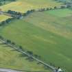
NH 550 442 During private flights in the summer of 2006, a cropmark site was observed 12km W of Inverness. The cereal crop revealed a number of linear features, some indicating probable field drains, but two of the ditches converge at an approximate right-angle, and are connected by a radiused corner. The site has a heavily 'pock-marked' appearance from the air, suggesting numerous pits in the area.
James S Bone, 2006.
Aerial Photography (2006)
NH 550 442 During private flights in the summer of 2006, a cropmark site was observed 12km W of Inverness. The cereal crop revealed a number of linear features, some indicating probable field drains, but two of the ditches converge at an approximate right-angle, and are connected by a radiused corner. The site has a heavily 'pock-marked' appearance from the air, suggesting numerous pits in the area.
J S Bone 2006

