
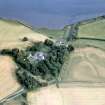
Tarradale House, Beauly


Pier (Period Unassigned)
Site Name Tarradale House, Beauly
Classification Pier (Period Unassigned)
Alternative Name(s) Beauly Firth
Canmore ID 293434
Site Number NH54NE 81
NGR NH 5530 4855
Datum OSGB36 - NGR
Permalink http://canmore.org.uk/site/293434


- Council Highland
- Parish Urray (Inverness)
- Former Region Highland
- Former District Inverness
- Former County Ross And Cromarty
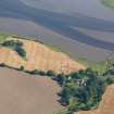
NH54NE 81 553 485
Pier with crane on the 1st edition of the OS 6-inch map (Ross and Cromarty, sheet xcix; 1881).
19th century AD or earlier.
Seen 23.9 Accretion. Overgrown.
CFA/MORA Coastal Assessment Survey 1998.

