
Pricing Change
New pricing for orders of material from this site will come into place shortly. Charges for supply of digital images, digitisation on demand, prints and licensing will be altered.
Skaill


Settlement (Viking)
Site Name Skaill
Classification Settlement (Viking)
Canmore ID 2932
Site Number HY50NE 19
NGR HY 5881 0651
NGR Description From HY 5881 0651 to HY 5881 0652
Datum OSGB36 - NGR
Permalink http://canmore.org.uk/site/2932


- Council Orkney Islands
- Parish St Andrews And Deerness
- Former Region Orkney Islands Area
- Former District Orkney
- Former County Orkney
Skaill 2 (St Mary), Deerness, Orkney, cross-slab fragment
Measurements: H 0.33m, W 0.32m, D 0.05m
Stone type: sandstone
Place of discovery: HY 5881 0651
Present location: The Orkney Museum, Kirkwall (OM 79.2)
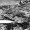
Evidence for discovery: found face down re-used in a paved path leading to primary Norse house 1 on Site 2, during excavations in 1979. It is likely to have come from the nearby churchyard.
Present condition: broken and worn.
Description
The fragment belongs to the lower part of a slightly tapering slab, on which is incised the shaft of a cross set on a pedestal base. The cross is indicated by a single line, and there survives the tip of a loop which is likely to be hanging from the right-hand arm.
Date: seventh century.
References: Buteux 1997, 108, 131, no 3001; Scott & Ritchie 2014, no 26.
Compiled by A Ritchie 2017
HY50NE 19 5881 0651 to 5881 0652
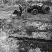
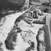
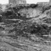
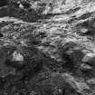
A Norse settlement, including the foundations of a 12th c Viking square stone tower, has been excavated at Skaill farm by the Ministry of Works and by Birmingham University.
The existence of a Viking residence and the halls of Amundi and Thorkel at the farm has been suggested by the place-name, and by the 11th century references in the Orkneyinga Saga.
S H Cruden 1960; The Scotsman 2 July 1963.
The excavations (1960-1963) have revealed two dry stone settlements at HY 5881 0651 and HY 5884 0644. A comb, found by Mr J R Foubister of Skaill, Deerness, Orkney in 1961 at HY 5881 0652 is in "an Edinburgh Museum".
The excavations are not yet complete.
Surveyed at 1/2500
Visited by OS (RD) 31 August 1964
The excavation at HY 5881 0651 has been filled in and there is no trace of structure. Most of the buildings at HY 5884 0644 survive, but are likely to be filled in shortly. According to Mr Foubister the excavators changed their minds about classifying a thick-walled building at the latter grid as a Norse tower. The excavations were completed in 1972.
Revised at 1/2500
Visited by OS (AA) 23 May 1973
The farmstead of Skaill, associated with the site of one of Orkney's most remarkable medieval churches (HY50NE 18), occupies the site of Hlaupandanes, the seat of Thorkel Fostri, a leading supporter of Earl Thorfinn the Mightly (ruled 1020-65). In the early 1960s, Mr J R Foubister reported that, in extracting lime-sand from the links immediately north of the wooden hen-house that forms the N boundary of the farmyard, he had encountered buildings. Mr Foubister suspended his sand-removal to allow excavation by the late Mr P S Gelling of Birmingham University. This grew into a long-term project which ran through the 1970s, in the course of which further Norse and later buildings were investigated in the farmyard itself, and substantial remains of prehistoric settlements were located and excavated both near to the church and, in the opposite direction, in two of the home fields 200m NW of the farmstead. Mr Gelling's account of the Viking-period buildings recently appeared in the National Museum's bicentennial volume, while the prehistoric material, left unfinished at his death, is currently being prepared for publication by Mr S Buteux.
The area of the inital discovery (HY 5882 0650) contained late Pictish buildings which were replaced, apparently without any gradual transition, by some not very well-built early Norse houses. The Pictish phases produced a fragment of an incised cross-slab re-used as a paving stone. A more substantial Norse building, probably a steam-bath, was excavated in the farmyard at the SE corner of the hen-house (HY 5883 0647) and a glimpse of what may have been the main eleventh-century house was obtained E of the byre (HY 5886 0645), below a very substantial rectilinear hall-type building possibly of thirteenth-century date. Viking-period structures also underlay a group of sixteenth-century buildings E of the hen-house (HY 5884 0648).
To the NW of the church and close beside the bungalow (HY 5881 0638), there was a considerable open-area excavation of substantial late Bornze Age settlement which lay immediately below the ploughsoil. At the same time a trial trench was dug into the prominent mound known as the Howan (HY 5890 0633) SE of the church, which in 1930 was suggested as the site of a broch, and a dark deposit observed in the eroding shoreline. The Howan proved to be a sand-dune and the deeply-buried dark deposit is an ancient ploughsoil, in which ard-marks, probably of Bronze Age date, were found. In 1982, Mr Foubister encountered fragmentary prehistoric buildings between the Howan and the SE corner of the Churchyard dyke (HY 5886 0635)
The latter years of the project were devoted to examining a muti-period settlement complex which began in the Late Bronze Age and continued through the Iron Age into a seventh-century AD Pictish context; it was situated about 200m NW of the farmstead (HY 5865 0657), an area spanning the fence between two fields.
Orkneyinga Saga; Taylor 1931; RCAHMS 1946; K A Steedman 1980; P S Gelling 1984; P S Gelling 1985; RCAHMS 1987
'The Orcadian' reported the excavation of the site in 1864.

