
Pricing Change
New pricing for orders of material from this site will come into place shortly. Charges for supply of digital images, digitisation on demand, prints and licensing will be altered.
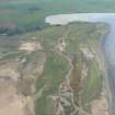
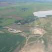
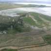
Castle Stuart


Pit(S) (Bronze Age), Roundhouse(S) (Prehistoric), Finger Ring (Enamel)(Iron Age), Rim Sherd(S) (Bronze Age), Unidentified Flint(S) (Period Unassigned)
Site Name Castle Stuart
Classification Pit(S) (Bronze Age), Roundhouse(S) (Prehistoric), Finger Ring (Enamel)(Iron Age), Rim Sherd(S) (Bronze Age), Unidentified Flint(S) (Period Unassigned)
Canmore ID 292561
Site Number NH75SW 35
NGR NH 74040 50070
NGR Description NH 741 501 and NH 7401 5005
Datum OSGB36 - NGR
Permalink http://canmore.org.uk/site/292561


- Council Highland
- Parish Petty
- Former Region Highland
- Former District Inverness
- Former County Inverness-shire
Excavation (8 August 2007 - 21 September 2007)
NH 7401 5005 An excavation was conducted in August and September of 2007 to identify, excavate and record all features already exposed following a watching brief conducted by CFA Archaeology in May 2007. Two trenches were opened between 8 August–21 September 2007, the main excavation area with a measurement of c4470m2 and a smaller section immediately to the S c885m2. The watching brief had indicated a high
concentration of pits, but when investigated, a large proportion were in fact natural depressions filled with topsoil or anomalies attributed to tree root action. Several small pits containing worked flint and BA pottery were found, as well as a large, deep wattle-lined pit with a diameter of 3.50m and stakeholes arcing around the base circumference. Three well defined firepits were also excavated along with a partial curvilinear small ditch-like feature, increasing in depth from SE/NW.
Archive deposited with RCAHMS.
Funder: Castle Stuart Golf.
OASIS ID: highland4-33895
Excavation (August 2007 - September 2007)
An archaeological excavation was conducted during August and September 2007 to investigate and record the nature and extent of any archaeology likely to be affected by construction of a compound at Castle Stuart Golf Course, Inverness. A substantial wattle-lined underground storage pit was discovered.
A large number of other pits was investigated, but virtually all of these proved to be of natural origin, probably formed by tree roots. There were no recommendations for follow-up work.
Information from Highland Archaeological Services Ltd.
Excavation (May 2007)
NH 741 501 A watching brief and limited excavation were carried out in May 2007 during ground reduction work associated with the construction of a compound and access road at Castle Stuart Golf Course, Inverness. Preliminary results indicate that the site contains two roundhouses, five linear features and a
great number of pits of various sizes distributed across the site.
Archive deposited with RCAHMS, City of Edinburgh Council Archaeology Service SMR.
Funder: Castle Stuart LLP.
Artefact Recovery (2013)
NH 74 50 An enamelled Iron Age finger ring, which has seen heavy wear, was found near Castle Stuart. The hoop had broken in antiquity, and much of the enamelling is lost. Double-trumpet mouldings sit at the bezel-hoop junction. The enamelling has a base of opaque red with other colours set into it; surviving elements suggest they once formed a triskele. The multicoloured nature of these inlays suggests reuse of bits of glass beads. The findspot lies close to a known later prehistoric settlement (NH75SW 35).
Claimed as Treasure Trove (TT181/12), allocated to Inverness Museum
Fraser Hunter, National Museums Scotland, 2013
(Source: DES)

