Accessibility

Font Size

100% 150% 200%

Background Colour

Default Contrast
Close Reset

Arbroath, Addison Place, General

General View (Period Unassigned)

Site Name Arbroath, Addison Place, General

Classification General View (Period Unassigned)

Canmore ID 292127

Site Number NO64SW 463

NGR NO 63639 40794

Datum OSGB36 - NGR

Permalink http://canmore.org.uk/site/292127
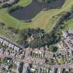
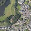
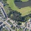
Ordnance Survey licence number AC0000807262. All rights reserved.
Canmore Disclaimer. © Bluesky International Limited 2025. Public Sector Viewing Terms

Toggle Aerial | View on large map

Digital Images

Oblique aerial view centred on the water tower with the high school adjacent, taken from the NE.
Oblique aerial view centred on the water tower with the high school adjacent, taken from the NE.Oblique aerial view centred on the water tower with the high school adjacent, taken from the NW.Oblique aerial view centred on the water tower, taken from the W.General oblique aerial view of Addison Place, centred on the water tower, taken from the ESE.Oblique aerial view centred on the water tower with the high school adjacent, taken from the SW.General oblique aerial view of Addison Place, centred on the water tower, taken from the SSE.General oblique aerial view of Addison Place, centred on the water tower, taken from the ENE.Oblique aerial view centred on the water tower with the high school adjacent, taken from the S.

Collections

Administrative Areas

  • Council Angus
  • Parish Arbroath And St Vigeans
  • Former Region Tayside
  • Former District Angus
  • Former County Angus

References

MyCanmore Image Contributions


Contribute an Image

MyCanmore Text Contributions