
Following the launch of trove.scot in February 2025 we are now planning the retiral of some of our webservices. Canmore will be switched off on 24th June 2025. Information about the closure can be found on the HES website: Retiral of HES web services | Historic Environment Scotland
Dumbarton And Old Kilpatrick


Bomb Crater(S) (20th Century)
Site Name Dumbarton And Old Kilpatrick
Classification Bomb Crater(S) (20th Century)
Alternative Name(s) Auchenreoch Decoy Site
Canmore ID 291876
Site Number NS47NW 70
NGR NS 41997 78096
Datum OSGB36 - NGR
Permalink http://canmore.org.uk/site/291876


- Council West Dunbartonshire
- Parish Dumbarton
- Former Region Strathclyde
- Former District Dumbarton
- Former County Dunbartonshire
NS47NW 70 41997 78096 and 41934 78173
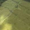
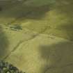
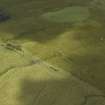
A possible bomb crater has been identified from oblique aerial photographs taken in September 2007 (RCAHMS 2007), and are situated on moorland bounded by Murroch Glen, Auchenreoch Glen and Square Wood. Two craters are depicted on the OS 1:2500 digital maps as 'ponds', both being filled with water. The largest of the craters has an approximate diameter of 10m, the other to the N measures about 9m.
The bomb craters form part of a group of at least eight bomb craters noted on vertical air photographs taken in 1949 (58/A/419: 5199, 5200) flown on 19 June 1949).
Information from RCAHMS (DE), December 2007
Note (12 April 2017)
Additional 103 bomb craters have been identified from RAF vertical air photography in map square NS47NW. Most of them are located between Dumbarton and Bonhill east of A813.
Information from HES (AL) 12 April 2017.

