
Following the launch of trove.scot in February 2025 we are now planning the retiral of some of our webservices. Canmore will be switched off on 24th June 2025. Information about the closure can be found on the HES website: Retiral of HES web services | Historic Environment Scotland
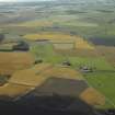
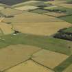
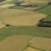
Kingsmuir Airfield


Airfield (20th Century)
Site Name Kingsmuir Airfield
Classification Airfield (20th Century)
Alternative Name(s) Sorbie; Kingsmuir House
Canmore ID 291297
Site Number NO50NW 51
NGR NO 53635 08694
NGR Description Centred NO 53635 08694
Datum OSGB36 - NGR
Permalink http://canmore.org.uk/site/291297


- Council Fife
- Parish Crail
- Former Region Fife
- Former District North East Fife
- Former County Fife
NO50NW 51 centred 53635 08694
A small grass airstrip is situated between the farmsteads of Sorbie and Kingsmuir House (NO50NW 35). The airstrip is used for aircraft taking people on parachuting jumps.
The airstrip has been only recently created.
Information from RCAHMS (DE), November 2007

