
Balnabroich


Pitcarmick Building(S) (Early Medieval)
Site Name Balnabroich
Classification Pitcarmick Building(S) (Early Medieval)
Alternative Name(s) Stylemouth
Canmore ID 29103
Site Number NO15NW 58
NGR NO 10515 57043
NGR Description NO 1056 5700 and NO 1052 5703
Datum OSGB36 - NGR
Permalink http://canmore.org.uk/site/29103


- Council Perth And Kinross
- Parish Kirkmichael (Perth And Kinross)
- Former Region Tayside
- Former District Perth And Kinross
- Former County Perthshire
Field Visit (5 May 1987)
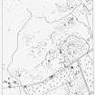
NO15NW 58 1053 5701 to 1051 5703.
Situated on heather moorland about 480m E of the Grey Cairn (NO 15 NW 1), there are the remains of two buildings. That on the SSE (NO 1056 5700) measures about 15m in length (NW-SE) by a maximum of 7.1m in width over walls reduced to low banks up to 1.3m in thickness and 0.3m in height. The building narrows slightly towards the SE, where there are possible traces of a partition. The position of the entrance is marked by a thickening of the wall, probably the remains of a porch, midway along the SW side.
On the NW there is an attached enclosure which measures 13m N-S by 10.8m within a wall reduced to a turf-covered stony bank up to 1.9m in thickness and 0.6m in height. This wall springs from the N corner of the building and returns adjacent to the entrance.
Situated about 40m to the NNW, the second building (NO 1052 5703) measures 12.3m in length by a maximum of 4m in width at the centre within walls reduced to banks up to 2.5m in thickness and 0.3m in height. The building narrows towards the SE and there is an entrance (1.2m wide) midway along the SW side.
Visited by RCAHMS (JRS) 5 May 1987.
RCAHMS 1990.
Measured Survey (1987)
RCAHMS surveyed the hut circles, field system and Pitcarmick-type buildings at Balnabroich in 1987 at a scale of 1:2500. The resultant plan was redrawn in ink and published at a scale of 1:5000 (RCAHMS 1990, Fig. 108A).
Measured Survey (1988)
RCAHMS surveyed a Pitcarmick-type building and enclosure (NO 1056 5700) at Balnabroich in 1988 at a scale of 1:250 with self-reducing alidade and plane-table. The site plan was redrawn in ink and published at a scale of 1:500 (RCAHMS 1990, Fig. 227.2B).
Measured Survey (1988)
RCAHMS surveyed a building (NO 1052 5703) at Balnabroich in 1988 at a scale of 1:250 with self-reducing alidade and plane-table. The site plan was redrawn in ink and published at a scale of 1:500 (RCAHMS 1990, Fig. 227.2A).

