
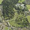
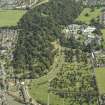
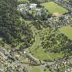
Dundee, Balgay Cemetery


Cemetery (19th Century)
Site Name Dundee, Balgay Cemetery
Classification Cemetery (19th Century)
Alternative Name(s) Western Necropolis; Balgay House Policies; Balgay Hill
Canmore ID 290325
Site Number NO33SE 629
NGR NO 37220 30673
Datum OSGB36 - NGR
Permalink http://canmore.org.uk/site/290325


- Council Dundee, City Of
- Parish Dundee (Dundee, City Of)
- Former Region Tayside
- Former District City Of Dundee
- Former County Angus
NO33SE 627 centred 3735 3065
For access footbridge (from Balgay Park, to E), see NO33SE 540.01.
Western Necropolis [NAT]
OS 1:1250 map, 1965.
Balgay Cemetery [NAT]
OS (GIS) AIB, June 2006.
This cemetery has been formed from the western part of the policies of Balgay House (NO33SE 194.01).
Information from RCAHMS (RJCM), 7 June 2006.
Note (13 February 2012)
Site not be confused with Western Cemetary (NO32NE 72.00) located on Perth Road, Dundee.
Information from RCAHMS (HDS) 13 February 2012
Note (11 October 2024)
A cemetery is depicted on the 1st edition of the OS 25-inch map (1884) - Forfarshire LIII.8 (Liff and Benvie, and Dundee - Combined).
Information from HES (D Watson) 11 October 2024

