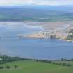
Accessibility

Font Size

100% 150% 200%

Background Colour

Default Contrast
Close Reset

Nigg Ferry

Quay (Period Unassigned)

Site Name Nigg Ferry

Classification Quay (Period Unassigned)

Alternative Name(s) Cromarty Firth; Firth Of Cromarty

Canmore ID 289899

Site Number NH76NE 316

NGR NH 7965 6879

Datum OSGB36 - NGR

Permalink http://canmore.org.uk/site/289899

Ordnance Survey licence number AC0000807262. All rights reserved.
Canmore Disclaimer. © Bluesky International Limited 2025. Public Sector Viewing Terms

Toggle Aerial | View on large map

Digital Images

Aerial view of Cromarty House, Cromarty, Nigg and Nigg Bay, looking NW.
Aerial view of Cromarty House, Cromarty, Nigg and Nigg Bay, looking NW.Oblique aerial view of the Cromarty Firth.Aerial view of Nigg Ferry, Cromarty Firth, looking NW.Aerial view of Nigg Fabrication Yard & Nigg Ferry, Cromarty Firth, looking NW.Aerial view of Nigg WW2 Submarine Mine Depot and Magazine, Cromarty Firth, looking N.

Administrative Areas

  • Council Highland
  • Parish Nigg (Ross And Cromarty)
  • Former Region Highland
  • Former District Ross And Cromarty
  • Former County Ross And Cromarty

Archaeology Notes

NH76NE 316 7965 6879

For storehouse at NH 7968 6882, see NH76NE 42.

For pillbox at NH 79652 68756, see NH76NE 292.

A sandstone block built quay facing onto present sandy beach immediately to East of Nigg Ferry slipway and directly in front (3m) of WWII pillbox [NH76NE 292]. Probably contemporary with storehouses to rear.

CFA/MORA Coastal Assessment Survey 1998.

References

MyCanmore Image Contributions


Contribute an Image

MyCanmore Text Contributions