
Scheduled Maintenance
Please be advised that this website will undergo scheduled maintenance on the following dates: •
Tuesday 3rd December 11:00-15:00
During these times, some services may be temporarily unavailable. We apologise for any inconvenience this may cause.
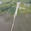
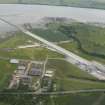
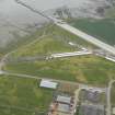
Evanton Airfield, Pier


Pier (20th Century)(Possible)
Site Name Evanton Airfield, Pier
Classification Pier (20th Century)(Possible)
Alternative Name(s) Cromarty Firth
Canmore ID 289289
Site Number NH66NW 81
NGR NH 629 666
Datum OSGB36 - NGR
Permalink http://canmore.org.uk/site/289289


- Council Highland
- Parish Kiltearn
- Former Region Highland
- Former District Ross And Cromarty
- Former County Ross And Cromarty
NH66NW 81 629 666
Long spit of grass extending out into saltmarsh and mud. May be WWII pier or just a shingle spit. Not possible to tell the construction or fill of pier.
CFA/MORA Coastal Assessment Survey 1998.

