
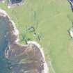
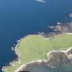
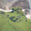
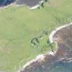
Inch Kenneth


Field System (Period Unassigned), Rig And Furrow (Medieval) - (Post Medieval)
Site Name Inch Kenneth
Classification Field System (Period Unassigned), Rig And Furrow (Medieval) - (Post Medieval)
Canmore ID 289269
Site Number NM43NW 41
NGR NM 4354 3567
NGR Description Centred on NM 4354 3567
Datum OSGB36 - NGR
Permalink http://canmore.org.uk/site/289269


- Council Argyll And Bute
- Parish Kilfinichen And Kilvickeon
- Former Region Strathclyde
- Former District Argyll And Bute
- Former County Argyll
NM43NW 41 4354 3567 (Centred)
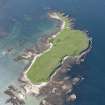
The field-system and blocks of rig, which are situated on the NW of Inch Kenneth, have been recorded on oblique aerial photography (RCAHMSAP 2007).
Information from RCAHMS (VLW) 22 June 2007

