
Pricing Change
New pricing for orders of material from this site will come into place shortly. Charges for supply of digital images, digitisation on demand, prints and licensing will be altered.
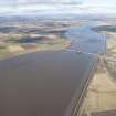
Kincardine On Forth, Kincardine, Clackmannanshire Bridge


Road Bridge (21st Century)
Site Name Kincardine On Forth, Kincardine, Clackmannanshire Bridge
Classification Road Bridge (21st Century)
Alternative Name(s) Upper Forth Crossing; Higgins Neuk; River Forth
Canmore ID 289181
Site Number NS98NW 342
NGR NS 92026 87762
NGR Description NS c. 9206 8836 to NS c. 9201 8693
Datum OSGB36 - NGR
Permalink http://canmore.org.uk/site/289181


- Council Fife
- Parish Tulliallan
- Former Region Fife
- Former District Dunfermline
- Former County Fife
NS98NW 342 c. 9206 8836 to c. 9201 8693
Not to be confused with earlier (swinging) Kincardine on Forth Bridge built downstream at NS 92134 86942 to NS 92831 87305: see NS98NW 59.
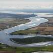
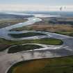
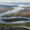
The new Clackmannanshire Bridge (Kincardine Bridge, upper Forth crossing), built between 2006 and 2008, opened 2008.
The bridge has been built N-S across the the River Forth from Higgins Neul roundabout to the Kennet Pans with the N approach road rejoining the A 977 anout 779m NNE of Kilbagie Mill (NS98NW 58).
(Undated) information in NMRS.
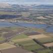
Archaeological Evaluation (November 2005 - February 2006)
Headland Archaeology was commissioned by Historic Scotland on behalf of the Scottish Executive to undertake an evaluation of the Upper Forth Crossing at Kincardine in advance of the construction of a new bridge and road, covering the route OS NGR NS 93261 90631 to NS 90419 85656. Phase 1 of the evaluation indicated two sites that would be affected by the proposed road scheme. The first is located at the northern end of the scheme and comprises features of Iron Age and medieval date within an area of 2.1 hectares. The second comprised the remains of a largely demolished 17th century laird’s house and buildings at Garlet. The evaluation has identified archaeological remains that pre-date the existing house and associated structures. Elsewhere within the corridor the remains of rig and furrow cultivation, of probable medieval date, were recorded on the carse areas either side of the River Forth. In addition, the possible remains of Second World War glider traps were recorded on the south side of the River.

