
Following the launch of trove.scot in February 2025 we are now planning the retiral of some of our webservices. Canmore will be switched off on 24th June 2025. Information about the closure can be found on the HES website: Retiral of HES web services | Historic Environment Scotland
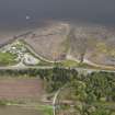
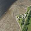
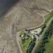
Foulis Point, Cromarty Firth


Fish Trap (Period Unassigned)(Possible), Pier (Period Unassigned)
Site Name Foulis Point, Cromarty Firth
Classification Fish Trap (Period Unassigned)(Possible), Pier (Period Unassigned)
Alternative Name(s) Firth Of Cromarty
Canmore ID 289108
Site Number NH56SE 50
NGR NH 5971 6340
Datum OSGB36 - NGR
Permalink http://canmore.org.uk/site/289108


- Council Highland
- Parish Kiltearn
- Former Region Highland
- Former District Ross And Cromarty
- Former County Ross And Cromarty
NH56SE 50 5971 6340
See also NH56SE 25.
Linear pier 40m long and 10m wide, perpendicular to shore. Find marked by concentration of rounded stones.
CFA/MORA Coastal Assessment Survey 1998.
This structure may form part of one of the fish traps that is noted under NH56SE 25.
Information from RCAHMS (RJCM), 19 June 2007.
Ground Survey (1998)
See also NH56SE 25.
Linear pier 40m long and 10m wide, perpendicular to shore. Find marked by concentration of rounded stones.
CFA/MORA Coastal Assessment Survey 1998.
Note (19 June 2007)
This structure may form part of one of the fish traps that is noted under NH56SE 25.
Information from RCAHMS (RJCM), 19 June 2007.

