
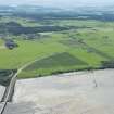
Balcladaich


Fish Trap (Period Unassigned)
Site Name Balcladaich
Classification Fish Trap (Period Unassigned)
Alternative Name(s) Cromarty Firth
Canmore ID 289005
Site Number NH55NE 178
NGR NH 5862 5947
NGR Description Centred NH 5862 5947
Datum OSGB36 - NGR
Permalink http://canmore.org.uk/site/289005


- Council Highland
- Parish Urquhart And Logie Wester
- Former Region Highland
- Former District Ross And Cromarty
- Former County Ross And Cromarty
NH55NE 178 centred 5862 5947
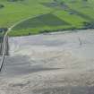
Fish trap (?)
A roughly curvilinear alignment of medium/large cobbles runs out from HWM for approximately 30m across mudflats at 90 degrees to shoreline. At 20m distant from High Water Mark alignment appears to possibly turn at 90 degrees upstream for some 20m. Visible only as seaweed covered occasional stony clumps.
CFA/MORA Coastal Assessment Survey 1998.
Ground Survey (1998)
Fish trap (?)
A roughly curvilinear alignment of medium/large cobbles runs out from HWM for approximately 30m across mudflats at 90 degrees to shoreline. At 20m distant from High Water Mark alignment appears to possibly turn at 90 degrees upstream for some 20m. Visible only as seaweed covered occasional stony clumps.
CFA/MORA Coastal Assessment Survey 1998.

