|
Manuscripts |
MS 726/167 |
Records of CFA Archaeology Ltd, archaeologists, Musselburgh, East Lothian, Scotland |
Coastal Assessment Survey: Inner Moray Firth, Volumes 1 and 2. |
14/12/1998 |
Item Level |
|
|
Manuscripts |
MS 2776/1/7 |
Historic Scotland Archive Project |
Survey archive: Site record sheets, site record sheets with field notes and monument forms from the Inner Moray Firth (Moray, Beauly and Cromarty Firth) Coastal Assessment Survey. Sheet 7. |
9/1998 |
Item Level |
|
|
Prints and Drawings |
BD 104/1/7 |
Historic Scotland Archive Project |
Survey archive: 1:25,000 OS Pathfinder map depicting site locations from the Moray, Beauly and Cromarty Firth Coastal Assessment Survey. Sheet 7. |
9/1998 |
Item Level |
|
 |
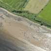
On-line Digital Images |
DP 191579 |
RCAHMS Aerial Photography Digital |
Oblique aerial view of the remains of the fish trap, looking SE. |
18/6/2014 |
Item Level |
|
 |
On-line Digital Images |
DP 191580 |
RCAHMS Aerial Photography Digital |
Oblique aerial view of the remains of the fish trap, looking SE. |
18/6/2014 |
Item Level |
|
|
Photographs and Off-line Digital Images |
BS 97/7 CS |
Historic Scotland Archive Project |
Survey photographs: From the Moray, Beauly and Cromarty Firth Coastal Assessment Survey ¿ Findon Mains, Castlecraig and Cullicudden. |
1998 |
Batch Level |
|


