
Pricing Change
New pricing for orders of material from this site will come into place shortly. Charges for supply of digital images, digitisation on demand, prints and licensing will be altered.
Edinburgh, Craigiehall House, Military Headquarters, Barracks


Barracks (20th Century), Building(S) (20th Century), Hut(S) (20th Century)
Site Name Edinburgh, Craigiehall House, Military Headquarters, Barracks
Classification Barracks (20th Century), Building(S) (20th Century), Hut(S) (20th Century)
Alternative Name(s) Goc Scotland; Craigiehall Estate; Craigiehall Policies
Canmore ID 288809
Site Number NT17NE 29.06
NGR NT 16823 75683
NGR Description Centred NT 16823 75683
Datum OSGB36 - NGR
Permalink http://canmore.org.uk/site/288809


- Council Edinburgh, City Of
- Parish Dalmeny
- Former Region Lothian
- Former District City Of Edinburgh
- Former County West Lothian
NT17NE 29.06 centred 16823 75683
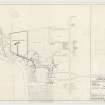
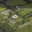
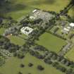
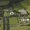
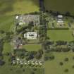
A group of buildings situated on level ground about 294m NE of Craigiehall House (NT17NE 29.00), which include four standard barrack blocks, soldiers dining room with kitchen and several other specialised buildings.
The four Barrack blocks of two stroreys are of the 'Chessington' type (Innes 1996), are orientated NW to SE, measure about 50m x 11m overall and have been provided with slated pitched roofs and a balcony at one end. All were completed to a modified design by Bowhill, Gibson and Laing in 1955. The four blocks are designated A to D and have now been given names. The dining room is also of a modified design having a pitched roof with slates.
One earlier building survives, a wooden single storey hut of World War II design (NT 16834 75640), which is now disused.
Visited by RCAHMS (DE, CJS), 22 May 2007

