
Balcladaith Wood


Fish Trap (Period Unassigned)
Site Name Balcladaith Wood
Classification Fish Trap (Period Unassigned)
Canmore ID 288426
Site Number NH55NE 165
NGR NH 5904 5982
Datum OSGB36 - NGR
Permalink http://canmore.org.uk/site/288426


- Council Highland
- Parish Urquhart And Logie Wester
- Former Region Highland
- Former District Ross And Cromarty
- Former County Ross And Cromarty
NH55NE 165 5904 5982
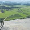
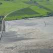
This fish trap, which is situated on the middle bank towards the S shore of the Cromarty Firth to the S of Cromarty road bridge, has been recorded on oblique aerial photography (RCAHMSAP 2007).
Information from RCAHMS (VLW) 26 April 2007
Aerial Photographic Interpretation (26 April 2007)
This fish trap, which is situated on the middle bank towards the S shore of the Cromarty Firth to the S of Cromarty road bridge, has been recorded on oblique aerial photography (RCAHMSAP 2007).
Information from RCAHMS (VLW) 26 April 2007

