
Pricing Change
New pricing for orders of material from this site will come into place shortly. Charges for supply of digital images, digitisation on demand, prints and licensing will be altered.
Scheduled Maintenance Notice
Please be advised that this website will undergo scheduled maintenance starting on Thursday, 30th January at 11:00 AM and will last until Friday, 31st January at 10:00 AM.
During this time, the site and certain functions may be partially or fully unavailable. We apologise for any inconvenience this may cause.
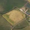
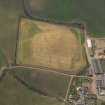
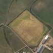
Meikle Pinkerton


Barrow (Prehistoric)(Possible), Pit(S) (Period Unknown)
Site Name Meikle Pinkerton
Classification Barrow (Prehistoric)(Possible), Pit(S) (Period Unknown)
Canmore ID 288079
Site Number NT77NW 100
NGR NT 70093 75530
Datum OSGB36 - NGR
Permalink http://canmore.org.uk/site/288079


- Council East Lothian
- Parish Dunbar
- Former Region Lothian
- Former District East Lothian
- Former County East Lothian
NT77NW 100 NT 70094 75531
Aerial Photographic Interpretation (6 October 2022)
A ring ditch, possibly a barrow of prehistoric date, has been recorded as cropmarking on oblique photographs (RCAHMSAP 2006) on the NE facing slope of Pinkerton Hill about 140m W of West Meikle Pinkerton Cottages. It is oval on plan, measuring about 3.5m from E to W by about 2.7m transversely, within a ditch about 1m broad. There is a scattering of pits and more amorphous cropmarks around.
Information from HES Archaeological Survey (F. Vermeij) 6 October 2022
Note (6 October 2022)
The location, classification and period of this site have been reviewed.

