 |
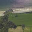
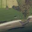
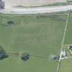
On-line Digital Images |
DP 021387 |
RCAHMS Aerial Photography Digital |
Obique aerial view centred on the remains of the chapel, burial ground and bombing range marker, taken from the NE. |
2/11/2006 |
Item Level |
|
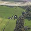 |
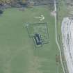
On-line Digital Images |
DP 021388 |
RCAHMS Aerial Photography Digital |
Oblique aerial view centred on the remains of the tower-house with the country house and remains of the church, burial ground and bombing range marker adjacent, taken from the NNE. |
2/11/2006 |
Item Level |
|
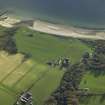 |
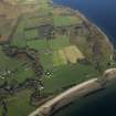
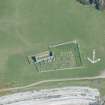
On-line Digital Images |
DP 021389 |
RCAHMS Aerial Photography Digital |
General oblique aerial view centred on the remains of the tower-house with the country house and remains of the church, burial ground and bombing range marker adjacent, taken from the N. |
2/11/2006 |
Item Level |
|
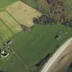 |
On-line Digital Images |
DP 021391 |
RCAHMS Aerial Photography Digital |
Oblique aerial view centred on the remains of the tower-house with the remains of the church, burial ground and bombing range marker adjacent, taken from the WSW. |
2/11/2006 |
Item Level |
|
 |
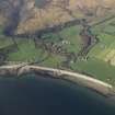
On-line Digital Images |
DP 021392 |
RCAHMS Aerial Photography Digital |
General oblique aerial view centred on the remains of the tower-house, the country house and remains of the church, burial ground and bombing range marker, taken from the SW. |
2/11/2006 |
Item Level |
|
 |
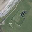
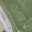
On-line Digital Images |
DP 021393 |
RCAHMS Aerial Photography Digital |
Obique aerial view centred on the remains of the chapel, burial ground and bombing range marker, taken from the SW. |
2/11/2006 |
Item Level |
|
 |
On-line Digital Images |
DP 021395 |
RCAHMS Aerial Photography Digital |
General oblique aerial view centred on the remains of the tower-house, the country house and remains of the church, burial ground and bombing range marker, taken from the SSE. |
2/11/2006 |
Item Level |
|
|
Manuscripts |
MS 4040 |
Records of CFA Archaeology Ltd, archaeologists, Musselburgh, East Lothian, Scotland |
Report: 'Coastal Zone assessment survey Kintyre & Isle of Arran'. |
1/2005 |
Item Level |
|
 |
On-line Digital Images |
DP 252828 |
Historic Environment Scotland |
Oblique aerial view. |
3/5/2017 |
Item Level |
|
 |
On-line Digital Images |
DP 252830 |
Historic Environment Scotland |
Oblique aerial view. |
3/5/2017 |
Item Level |
|
 |
On-line Digital Images |
DP 252833 |
Historic Environment Scotland |
Oblique aerial view. |
3/5/2017 |
Item Level |
|
 |
On-line Digital Images |
DP 252836 |
Historic Environment Scotland |
Oblique aerial view. |
3/5/2017 |
Item Level |
|
 |
On-line Digital Images |
DP 252837 |
Historic Environment Scotland |
Oblique aerial view. |
3/5/2017 |
Item Level |
|


