
Rynachulig


Farmstead (Period Unassigned), Kiln Barn (Period Unassigned)
Site Name Rynachulig
Classification Farmstead (Period Unassigned), Kiln Barn (Period Unassigned)
Canmore ID 287617
Site Number NN63NW 140
NGR NN 6173 3598
Datum OSGB36 - NGR
Permalink http://canmore.org.uk/site/287617


- Council Perth And Kinross
- Parish Kenmore (Perth And Kinross)
- Former Region Tayside
- Former District Perth And Kinross
- Former County Perthshire
NN63NW 140 6173 3598.
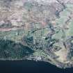
Rynachulig farmsteading now comprises a group of recently-constructed sheds immediately S of the A827 road at NN 6166 3623, but its predecessor stands about 250m to the S, at NN 6173 3598, where there is a group of 19th-century outbuildings, disused but still roofed.
About 80m E of those buildings, in a pasture field at NN 61831 35970, there is a kiln barn (BL00 710), measuring 10.5 from NNW to SSE by 4.8m transversely over rubble walls standing up to 2.1m high. The kiln bowl, at the NNW end, measures 2.5m in diameter and is filled with rubble to within 0.6m of its rim. The splayed flue opens to the SSE.
John Farquharson's 1769 Survey of the North Side of Loch Tay (National Archives of Scotland, RHP 973/1, Plan 5) depicts a township comprising seven buildings here, extending from the site of the 19th-century steading as far as the kiln barn (which appears to be one of the buildings depicted). The 1st edition of the OS 6-inch map (Perthshire 1867, sheet lxviii) depicts a farmstead comprising four roofed buildings and an enclosure, with a groundplan very similar to that of the W half of the 1769 township. The OS map also shows the kiln barn, though it is identified as a 'Limekiln'. The depiction of the steading on the 2nd edition of the OS map (Perthshire 1901, sheet lxviii SE) shows that further development took place in the late 19th century, and the recently-disused buildings noted above are shown on that map.
(BL00 710, 2582)
Visited by RCAHMS (ATW and MFTR) 5 July 2000 and (SDB) 10 March 2004.

