
Pricing Change
New pricing for orders of material from this site will come into place shortly. Charges for supply of digital images, digitisation on demand, prints and licensing will be altered.
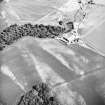
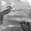
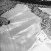
Cambusmichael


Enclosure (Period Unassigned)(Possible), Rig And Furrow (Medieval) - (Post Medieval)
Site Name Cambusmichael
Classification Enclosure (Period Unassigned)(Possible), Rig And Furrow (Medieval) - (Post Medieval)
Canmore ID 28674
Site Number NO13SW 46
NGR NO 1159 3232
Datum OSGB36 - NGR
Permalink http://canmore.org.uk/site/28674


- Council Perth And Kinross
- Parish St Martins
- Former Region Tayside
- Former District Perth And Kinross
- Former County Perthshire
NO13SW 46 1159 3232.
Air photography has recorded the indistinct cropmarks of a possible enclosure 100m NW of Cambusmichael steading and immediately NW of the enclosure NO13SW 42.
Information from RCAHMS (JRS) 15 December 1992.

