
Mansion Hill


Rig And Furrow (Medieval) - (Post Medieval)
Site Name Mansion Hill
Classification Rig And Furrow (Medieval) - (Post Medieval)
Canmore ID 286554
Site Number NT17NE 291
NGR NT 1628 7765
NGR Description Centred on NT 1628 7765
Datum OSGB36 - NGR
Permalink http://canmore.org.uk/site/286554


- Council Edinburgh, City Of
- Parish Dalmeny
- Former Region Lothian
- Former District City Of Edinburgh
- Former County West Lothian
NT17NE 291 1628 7765 (Centred)
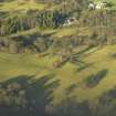
Two blocks of broad sinuous rig, which are situated to the S of Dalmeny House walled garden, have been recorded on oblique aerial photography (RCAHMSAP 2006). One block runs from N to S while the other runs from NW to SE.
Information from RCAHMS (VLW) 16 February 2007

