
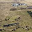
Cronberry Moor Colliery, Pit


Bing (Period Unassigned), Colliery (Period Unassigned)
Site Name Cronberry Moor Colliery, Pit
Classification Bing (Period Unassigned), Colliery (Period Unassigned)
Canmore ID 286550
Site Number NS62SW 30.01
NGR NS 6031 2281
Datum OSGB36 - NGR
Permalink http://canmore.org.uk/site/286550


- Council East Ayrshire
- Parish Auchinleck
- Former Region Strathclyde
- Former District Cumnock And Doon Valley
- Former County Ayrshire
NS62SW 30.01 6031 2281
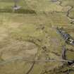
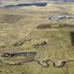
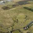
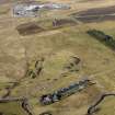
The remains of this coal pit, comprising the remains of a bing, have been recorded on oblique aerial photography (RCAHMSAP 2006). The coal pit is depicted on the 2nd edition OS 6-inch map (Ayrshire Sheet XXXVI.1, 1909) lying to the NW of Cronberry village.
Information from RCAHMS (VLW) 16 February 2007

