
Balnaguard


Long Cist Cemetery (Early Medieval)(Possible), Pit(S) (Period Unassigned)
Site Name Balnaguard
Classification Long Cist Cemetery (Early Medieval)(Possible), Pit(S) (Period Unassigned)
Canmore ID 286111
Site Number NN95SW 104
NGR NN 9455 5222
Datum OSGB36 - NGR
Permalink http://canmore.org.uk/site/286111


- Council Perth And Kinross
- Parish Little Dunkeld
- Former Region Tayside
- Former District Perth And Kinross
- Former County Perthshire
NN95SW 104 9455 5222
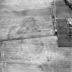
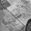
What may be a long cist cemetery has been recorded on oblique aerial photographs (RCAHMSAP 2001) as cropmarks lying on level ground to the S of the River Tay and about 350m NNW of Balnaguard Farm. A scatter of small pits is also visible.
Information from RCAHMS (MMB) 27 November 2006

