
Scheduled Maintenance
Please be advised that this website will undergo scheduled maintenance on the following dates: •
Tuesday 3rd December 11:00-15:00
During these times, some services may be temporarily unavailable. We apologise for any inconvenience this may cause.
Inchtuthil


Temporary Camp (Roman)
Site Name Inchtuthil
Classification Temporary Camp (Roman)
Alternative Name(s) Inchtuthil Plateau
Canmore ID 28594
Site Number NO13NW 5.02
NGR NO 1165 3934
Datum OSGB36 - NGR
Permalink http://canmore.org.uk/site/28594


- Council Perth And Kinross
- Parish Caputh
- Former Region Tayside
- Former District Perth And Kinross
- Former County Perthshire
NO13NW 5.02 1165 3934.
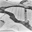
The cropmarks of a small Roman temporary camp have been recorded by aerial photography near the SW angle of the Inchtuthil plateau. It measures 119m by 79m, and at no point on the perimeter has a gap for an entrance been recorded. Although not securely dated, a Flavian date must be presumed from its context, and it has been suggested by Pitts and St Joeph that it may be the bivouac of an independent auxiliary force, perhaps a cavalry ala, which arrived at Inchtuthil after the large labour-camp had been laid out.
Information from RCAHMS (JRS) 9 December 1992.
L F Pitts and J K St Joseph 1985.
Publication Account (17 December 2011)
The Roman fortress and camps at Inchtuthil are situated on a plateau on the north side of the River Tay. The forts at Cargill lie some 4.5km to the ESE and the camp at Steeds Stalls some 3km to the NNW. The Cleaven Dyke, long believed to be a Roman earthwork but now recognised as a Neolithic cursus monument, lies about 4km to the east (Barclay and Maxwell 1998: 13–22).
The existence of the fortress on the plateau has long been known (eg, Roy 1793: Pl. XVIII), but the camps (II and III) known only through cropmarks on air photographs from the 1950s (St Joseph 1958: 91) (although photographs taken from 1945 onwards reveal elements of the camps (Pitts and St Joseph 1985: 223)). Camp I, situated at the western end of the plateau, was also recorded through cropmarks in the 1960s (St Joseph 1965: 82–3). The camps have more recently received attention, predominantly owing to the pits visible in the interior of ‘labour’ camps II and III (eg Hanson 1978a: 142; Maxwell 1981: 52–3; Maxwell 1982a; Wilson 1984: 55–7; Pitts and St Joseph 1985: 223–44; RCA HMS 1994: 77–82).
Camp I lies at the far west end of the plateau, immediately east of a promontory fort that has been proposed as post-Roman in date (Pitts and St Joseph 1985: 248). It has received little attention in comparison with the other two camps to the east, and it receives fairly brief mention in the Inchtuthil volume (Pitts and St Joseph 1985: 243, figs. 1 and 2). It measures about 119m from north to south by 75m transversely, enclosing 0.9ha (2.2 acres). No entrances are visible although only part of the east side has been recorded from the air (and recent geophysical survey failed to locate this east side, Hoffmann and Woolliscroft pers comm). Enough survives of the north and south ends to indicate that these had no central entrance gap.
Excavations on the ditch of the camp have been recorded in two sources but with differing dimensions: in a summary article, St Joseph noted that the ditch was ‘barely 4 ft wide by 2 ft deep’ (1965, 83), but in the Inchtuthil monograph he records that the ditch was ‘only 5 ft wide and 2 ft. 10 in. deep’ (Pitts and St Joseph 1985: 225). It is unclear how many trenches were placed, with just a single section of the west side drawn (Pitts and St Joseph 1985: fig 70). Thus it appears that the camp ditch measured 1.2– 1.5m in width and 0.6–0.86m in depth.
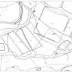
Camps II and III are the so-called ‘labour camps’ situated immediately west of the Roman fortress. Camp II occupies the space between camp I and the fortress, and camp III is a reduction of camp II , represented by an additional ditch on its south-west side. Camp II is almost a parallelogram in form, measuring 480m from WSW to ENE by 425m transversely, enclosing 19.8ha (49 acres). Camp III reduces the WSW to ENE dimension to 355m, with the area enclosed 14.8ha (36.6 acres). A plantation bisects the camps from north-west to south-east, and parts of the NNW side and south corner are also under trees. St Joseph placed trenches on the NNW side to determine its course through the plantation. These trenches recorded that the ditch averaged 2.7m in width and 0.76m in depth (Pitts and St Joseph 1985: 225, fig 69). Trenches determined the locations of entrance gaps in the NNW and SSE sides; an entrance gap is clearly visible close to the centre of the ENE side, and gaps are visible close to the centres of the WSW sides of both camps II and III. Further trenches were excavated on the ENE and the WSW sides (Pitts and St Joseph 1985: fig 70).
Numerous pits are visible within and outwith these camps. A series of pits runs parallel to the ENE side and the eastern part of the SSE side, and these have been interpreted as possible ovens. Rows of pits are also visible in the south-east part of the camps, and in the western part, west of the plantation strip. Nine pits in this latter area were excavated and interpreted as rubbish pits related to rows of tents. These have been used ingenuously to interpret the potential garrisons of the camps (Maxwell 1982a; Frere 1985c; Jones 2006).
Two other features are visible crossing camps II and III: the ‘Outer Masking Earthwork’ and the ‘Western Vallum’ (illus 146). The former is a line of ditch which seemingly demarcates the western part of the plateau, running almost north to south from the west corner of camp III through the entrance gap on the WSW side of camp II, at which point it turns slightly to the SSE. A trench through this feature revealed a V-shaped ditch measuring 1.93m in width and 0.63m in depth. Pitts and St Joseph believed that this was contemporary with the occupation of camp III (1985: 244–5), but RCAHMS preferred to see it as a further feature associated with the ‘Western Vallum’ (RCAHMS 1994: 81–2). This is an earthwork running NNW to SSE with a change of alignment partway along, running through the eastern part of camps II and III, with the rampart overlying the ditch of the SSE side of the camps, and accompanying ditch running through the entrance gap on this side (Pitts and St Joseph 1985: 245). This feature was visible in Roy’s day (1793: Pl. XVIII ) and is still visible as a slight earthwork. The excavated section indicated that the rampart was 0.68m in height (made of turf cheeks on a gravel core) and 6.7m in width. The ditch on the west side was V-shaped, 5.18m in width and 1.68m in depth. It is therefore later than the occupation of camps II and III (Pitts and St Joseph 1985: 245, fig 3).
There are no entrances visible in either earthwork, suggesting that the intention was to close off the plateau, either in succession (the ‘Outer Masking Earthwork’ being built before the ‘Western Vallum’) or contemporaneously. Some of the pits spread across the plateau may relate to occupation within these earthworks, which may demarcate areas for settlement and other forms of activity. Whichever scenario was the case, it is also probable that camp I predated the construction of either earthwork, because these would have blocked access from this camp to the rest of the plateau. Frere commented that the camp had the appearance of a late arrival encamped on the only available ground, possibly for a separate auxiliary force, perhaps an ala. He dismissed the suggestion that the camp could represent a reconnaissance force on the plateau (Frere 1985c: 243). However, it is sited on the highest point, the best location for survey, and this proposal remains entirely plausible (see above, section 7e).
R H Jones

