
Pricing Change
New pricing for orders of material from this site will come into place shortly. Charges for supply of digital images, digitisation on demand, prints and licensing will be altered.
Inchtuthil


Drain(S) (Period Unknown), Field Boundary (Period Unknown), Flood Defences (Period Unknown)
Site Name Inchtuthil
Classification Drain(S) (Period Unknown), Field Boundary (Period Unknown), Flood Defences (Period Unknown)
Canmore ID 28570
Site Number NO13NW 17
NGR NO 122 388
Datum OSGB36 - NGR
Permalink http://canmore.org.uk/site/28570


- Council Perth And Kinross
- Parish Caputh
- Former Region Tayside
- Former District Perth And Kinross
- Former County Perthshire
NO13NW 17 122 388.
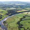
Linear cropmarks have been noted on air photographs to the SW of the Roman fortress NO13NW 5.00.
Information from RCAHMS (JRS) 7 January 1993.
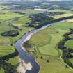
Field boundaries, a flood defence and what may be drains have been recorded as both cropmarks and earthworks on oblique aerial photographs (RCAHMSAP 1981) on this low-lying piece of ground on the N bank of the River Tay.
Information from RCAHMS (OGS) 30 April 2008

