
Pricing Change
New pricing for orders of material from this site will come into place shortly. Charges for supply of digital images, digitisation on demand, prints and licensing will be altered.
West Broomley


Pit(S) (Prehistoric), Rig And Furrow (Medieval) - (Post Medieval), Unenclosed Settlement (Prehistoric)
Site Name West Broomley
Classification Pit(S) (Prehistoric), Rig And Furrow (Medieval) - (Post Medieval), Unenclosed Settlement (Prehistoric)
Alternative Name(s) House Of Dun Policies
Canmore ID 285665
Site Number NO65NE 125
NGR NO 6785 5974
Datum OSGB36 - NGR
Permalink http://canmore.org.uk/site/285665


- Council Angus
- Parish Dun
- Former Region Tayside
- Former District Angus
- Former County Angus
NO65NE 125 6785 5974
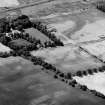
This unenclosed settlement, which is situated N of Broomley country house, has been recorded as cropmarks in oblique aerial photography (RCAHMSAP 2001). Rig, aligned approximately from NNW to SSE extends across the field.
Information from RCAHMS (VLW) 12 December 2006

