
Following the launch of trove.scot in February 2025 we are now planning the retiral of some of our webservices. Canmore will be switched off on 24th June 2025. Information about the closure can be found on the HES website: Retiral of HES web services | Historic Environment Scotland
Kirk O' The Muir, United Presbyterian Manse


Manse (19th Century)
Site Name Kirk O' The Muir, United Presbyterian Manse
Classification Manse (19th Century)
Alternative Name(s) Kinclaven, United Presbyterian Manse
Canmore ID 28562
Site Number NO13NW 10
NGR NO 11144 36938
Datum OSGB36 - NGR
Permalink http://canmore.org.uk/site/28562


- Council Perth And Kinross
- Parish Kinclaven
- Former Region Tayside
- Former District Perth And Kinross
- Former County Perthshire
NO13NW 10 11144 36938
For associated church (NO 1121 3704), see NO13NW 60.
Manse [NAT]
OS 1:10,560 map, 1867.
'A little to the south [of the church] is the manse, a plain house with offices, vegetable garden and a small portion of ornamental ground attached.'
Name Book, 1864.
Standing Building Recording (1 April 2019)
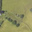
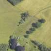
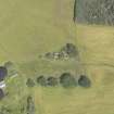
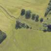
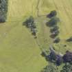
Kirk O’ The Muir manse lies to the South of the road from Murthly to Kinclaven and on the northern side of Taymount Wood. The three buildings (Manse A, byre B and garden shed C) are enclosed by a drystone wall and are approached by a farm track from the North.
The planning consent for a development included an archaeological condition specifying the need for a standing building record of buildings at Kirk O’ The Muir manse using ALGAO Scotland’s Historic Building Recording Guidance (2013). This standing building survey was carried out by the author on Monday 1st April 2019 (Site Code KOM01), weather conditions were slightly overcast.
Information from D Hall (2019)
NO 11144 36938 A photographic and written survey were carried out of the 19th century building complex at Kirk O’ The Muir Manse (Canmore ID: 28562) on 1 April 2019. Written descriptions were made of external and internal elevations and fittings.
Archive: NRHE (intended)
Funder: Private individual
Derek Hall
(Source: DES Vol 20)
OASIS ID: derekhal1-346666

