
Pricing Change
New pricing for orders of material from this site will come into place shortly. Charges for supply of digital images, digitisation on demand, prints and licensing will be altered.
Cargill, Old Parish Church


Burial Enclosure (19th Century), Burial Ground (Medieval), Church (Medieval), Sundial(S) (17th Century)
Site Name Cargill, Old Parish Church
Classification Burial Enclosure (19th Century), Burial Ground (Medieval), Church (Medieval), Sundial(S) (17th Century)
Alternative Name(s) Cargill Old Churchyard
Canmore ID 28554
Site Number NO13NE 83
NGR NO 15005 36995
Datum OSGB36 - NGR
Permalink http://canmore.org.uk/site/28554


- Council Perth And Kinross
- Parish Cargill
- Former Region Tayside
- Former District Perth And Kinross
- Former County Perthshire
Field Visit (June 1990)
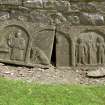
A 19th-century burial-enclosure stands upon the site of the medieval parish church of Cargill, although the outline of the church is visible to the W of the enclosure, its N side appearing as a slight bank. Incorporating numerous squared blocks, the enclosure may have been built in part from stone taken from the church; in the S wall, there is a possible voussoir and at the S corner there is what is probably a chamfered lintel. Within the burial-enclosure there is a 17th-century gravestone (George Wright of Laton, died 1692), and against the outer face of the W wall there is a side panel from a table tomb bearing depictions of Adam and Eve, Abraham and Isaac and the goat trapped in the bush. Elsewhere in the burial-ground there are numerous 18th-century gravestones, whilst over the entrance there is a 17th-century sundial; a second sundial (NO13NW 13.01), taken from Cargill manse, has been erected upon a pedestal close to the SE corner of the burial-ground. The church is on record by 1195x99. In 1794 the minister of Cargill stated that it was uncertain when the church was built, but that 'part of it appears very old' (OSA). In 1831 the present church (NO13NE 99) was built about 50m to the S of the burial-ground. Visited by RCAHMS (PC) June 1990. Reg Reg Scot; Stat Acct 1791; New Statistical Account 1845; B Willsher 1987.
Earth Resistance Survey (13 June 2007 - 28 June 2007)
NO 1500 3699 A resistivity survey of the old churchyard between 13–28 June 2007 failed to find direct evidence of the former medieval chapel. A belt of high resistivity ground some 10m wide encircles the probable site and may represent spoil from foundation of the building or rubble from its demolition.
Archive to be deposited with RCAHMS. Copy of report deposited with Perth and Kinross SMR.

