
Pricing Change
New pricing for orders of material from this site will come into place shortly. Charges for supply of digital images, digitisation on demand, prints and licensing will be altered.
Hallhole


Plantation Bank (Period Unknown), Square Barrow (Iron Age)
Site Name Hallhole
Classification Plantation Bank (Period Unknown), Square Barrow (Iron Age)
Canmore ID 28475
Site Number NO13NE 10
NGR NO 18619 39088
Datum OSGB36 - NGR
Permalink http://canmore.org.uk/site/28475


- Council Perth And Kinross
- Parish Caputh
- Former Region Tayside
- Former District Perth And Kinross
- Former County Perthshire
NO13NE 10 1862 3908.
(NO 1862 3908) Praetorium (R)
OS 6" map (1901)
See also NO13NE 53 and NO13NE 70.
An enigmatic, probably symmetrical earthwork (see ground plan - Abercromby's "slight indication that there was once (also) an approach from the NW" receives some confirmation from the ONB, which says that "at each angle is an opening"). It is in a poor defensive position, and the banks and the contained area are clearly inadequate for defence. Abercromby's opinion that the mound contained 3 cinerary interments is hardly substantiated by the finds, which were of recent refuse and some fragments of unspecified bone and charcoal. Crawford, after visiting the site, was non-committal. A clue to its original purpose may, however, be contained in Abercromby's comment that at the time of his excavations the earthwork was a rabbit-warren. The stone slabs on edge which he found (see excavation plan) may have been the remains of traps or artificial runs.
J Abercromby 1904; G Chalmers 1810; W F Skene 1886
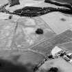
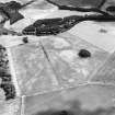
This near D-shaped earthwork situated on gently sloping pasture land, comprises three earth-and-stone banks, 0.5m-1.0m high, with medial ditches, and at the centre a circular earthen mound 15.0m in diameter and 0.5m high. There are causewayed entrances at each of the four corners - contrary to Abercromby's plan. Surrounding the work is a small bank which conforms exactly in shape, and may be contemporary.
The date and purpose of this earthwork could not be determined.
Re-surveyed at 1:2500.
Visited by OS (JP) 15 November 1970
Measured Survey (18 May 1989)
RCAHMS surveyed the square barrow at Hallhole (NO13NE 10) with plane-table and self-reducing adlidade on 18 May 1989 at a scale of 1:500. The resultant plan was redrawn in ink and published at a scale of 1:2500 (RCAHMS 1994b, 18(B)).
Field Visit (1 June 1992 - 30 June 1992)
What are probably the unploughed remains of a square barrow survive within a former plantation 500m ESE of Hallhole steading. The monument comprises a low central mound (about 10m across and 0.5m high) within twin ditches and external banks (up to 1m high). The plan of the ditches is roughly square, and there are well-defined causeways at the N, S and ESE, but there is no equivalent feature on the W. In places (particularly on the N) the outermost bank is obscured by that defining a later plantation. Although the form of the monument is unique among the upstanding earthworks of the region, the causeways across the angles of the ditches form a distinctive feature of smaller barrows and probably indicate its character. In 1903, excavation of the central mound revealed small concentrations of burnt bone and charcoal which were identified by the excavator as 'three cinerary interments'. McOmie's (1784) plan of the area depicts one monument as a 'redoubt' at the SE end of the Cleaven Dyke (NO13NE 89) but the Dyke is now believed to terminate 1.3km to the NW (and to be of Neolithic date). Cropmarks on air photographs have revealed at least one probable round barrow (NO13NE 53) immediately to the S, and it is probable that the square barrow has formed a single element of a more extensive cemetery.
Visited by RCAHMS (AW/SH) June 1992.
G Chalmers 1887-94; J Abercromby 1904.

