
Whitrope Summit Sidings And Signal Box


Railway Siding(S) (19th Century) - (20th Century), Signal Box (19th Century) - (20th Century)
Site Name Whitrope Summit Sidings And Signal Box
Classification Railway Siding(S) (19th Century) - (20th Century), Signal Box (19th Century) - (20th Century)
Alternative Name(s) The Waverley Line; The Border Uinion Railway
Canmore ID 284532
Site Number NT50SW 11.05
NGR NT 52561 00148
Datum OSGB36 - NGR
Permalink http://canmore.org.uk/site/284532


- Council Scottish Borders, The
- Parish Castleton
- Former Region Borders
- Former District Roxburgh
- Former County Roxburghshire
NT50SW 11.05 52561 00148
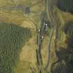
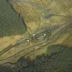
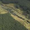
Whitrope summit signal box and refuge sidings. The area was cleared following closure of the line, but a preservation group has relayed a section of track and an interpretation centre about The Waverley Line has been opened in a railway carriage.
The signal box has been demolished.

